
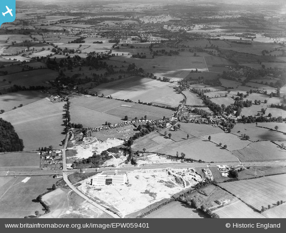
EPW059401 ENGLAND (1938). The Harts Spring Gravel Pits and the village, Patchetts Green, from the south-west, 1938
© Copyright OpenStreetMap contributors and licensed by the OpenStreetMap Foundation. 2026. Cartography is licensed as CC BY-SA.
Nearby Images (15)
EPW059401

EAW048408

EAW048406

EAW048406
EAW025278

EAW048407

EAW025270

EAW025277

EAW025274

EAW025272

EAW025268

EAW048404

EAW048404
EAW025273

EAW025276

Details
| Title | [EPW059401] The Harts Spring Gravel Pits and the village, Patchetts Green, from the south-west, 1938 |
| Reference | EPW059401 |
| Date | 15-September-1938 |
| Link | |
| Place name | PATCHETTS GREEN |
| Parish | |
| District | |
| Country | ENGLAND |
| Easting / Northing | 513603, 197464 |
| Longitude / Latitude | -0.35725846830494, 51.663993184441 |
| National Grid Reference | TQ136975 |
Pins

Bluid |
Tuesday 22nd of December 2020 11:57:31 AM | |
|
Bluid |
Friday 2nd of May 2014 08:25:17 AM | |
 |
Bluid |
Monday 14th of October 2013 06:25:35 PM |
Picture taken from 1937 Watford Observer. Used as a scout hut in the 60s |
Bluid |
Monday 14th of October 2013 06:29:03 PM |
|
Bluid |
Monday 14th of October 2013 06:21:26 PM | |
|
Bluid |
Monday 14th of October 2013 05:34:06 PM | |
|
Bluid |
Monday 14th of October 2013 05:33:26 PM | |
|
Bluid |
Monday 14th of October 2013 05:28:30 PM |


User Comment Contributions
Four Want Ways |
Bluid |
Monday 14th of October 2013 07:10:09 PM |
The site of these gravel pits is bounded by Hartspring Lane on the left and what is now the A41 (running left to right in the bottom third of the picture. The site now houses COSTCO, Hilton Hotel, a Traveler site and Winfield Garden & Building Supplies. Patchetts Green is to the right of centre in the photo. |
Brian H |
Saturday 24th of August 2013 01:40:10 PM |