
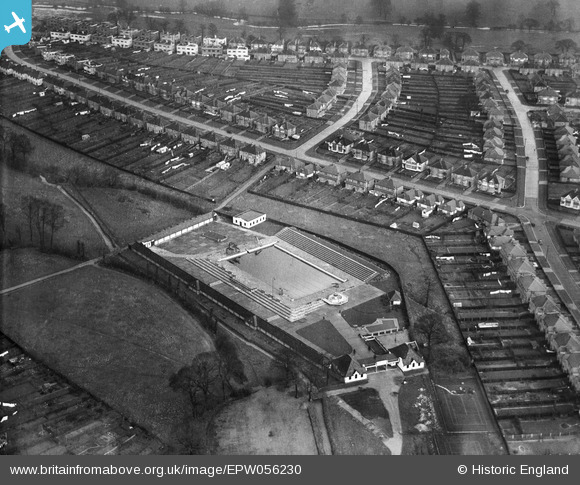
EPW056230 ENGLAND (1937). Surbiton Lagoon, Berrylands, 1937
© Copyright OpenStreetMap contributors and licensed by the OpenStreetMap Foundation. 2026. Cartography is licensed as CC BY-SA.
Nearby Images (2)
EPW056230

EPR000452

Details
| Title | [EPW056230] Surbiton Lagoon, Berrylands, 1937 |
| Reference | EPW056230 |
| Date | 14-December-1937 |
| Link | |
| Place name | BERRYLANDS |
| Parish | |
| District | |
| Country | ENGLAND |
| Easting / Northing | 519840, 167209 |
| Longitude / Latitude | -0.27740798608793, 51.390754216728 |
| National Grid Reference | TQ198672 |
Pins

Karen |
Wednesday 7th of October 2020 08:23:46 AM | |
|
marty |
Thursday 24th of December 2015 07:19:47 AM | |
|
DMK |
Monday 1st of June 2015 08:22:50 PM | |
|
DMK |
Monday 1st of June 2015 08:21:32 PM | |
|
DMK |
Monday 1st of June 2015 08:20:34 PM | |
|
DMK |
Tuesday 24th of March 2015 03:09:09 PM | |
|
kjc |
Thursday 2nd of October 2014 10:23:43 AM | |
This is not Meldone Close, which was not even built when the photo was taken. It is Waverley Avenue. |
DMK |
Tuesday 24th of March 2015 03:06:12 PM |
|
kjc |
Thursday 2nd of October 2014 10:21:04 AM | |
Not Northcote but Greenfield Avenue. |
DMK |
Tuesday 24th of March 2015 03:08:03 PM |
|
kjc |
Thursday 2nd of October 2014 10:14:51 AM | |
Not Raeburn Avenue but Grand Avenue. |
DMK |
Tuesday 24th of March 2015 03:06:55 PM |
|
David Wraith |
Friday 6th of December 2013 09:27:34 AM |
User Comment Contributions
The "pinned" roads in this picture have been given the wrong identities. I have made the appropriate amendments in replies to each one. |
DMK |
Tuesday 24th of March 2015 04:35:16 PM |