
EPW054904 ENGLAND (1937). East Dereham Urban District Council Sewage Works, Dereham, 1937

© Copyright OpenStreetMap contributors and licensed by the OpenStreetMap Foundation. 2026. Cartography is licensed as CC BY-SA.
Nearby Images (8)
EPW054904

EPW054907

EPW054909

EPW054906

EPW054903

EPW054908

EPW054910

EPW054905

Details
| Title | [EPW054904] East Dereham Urban District Council Sewage Works, Dereham, 1937 |
| Reference | EPW054904 |
| Date | 16-August-1937 |
| Link | |
| Place name | DEREHAM |
| Parish | DEREHAM |
| District | |
| Country | ENGLAND |
| Easting / Northing | 598015, 313553 |
| Longitude / Latitude | 0.92980314976416, 52.683075378704 |
| National Grid Reference | TF980136 |
Pins
Be the first to add a comment to this image!
User Comment Contributions
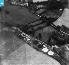
Dereham Sewage Works, Rush Meadow Road 1937 |
Sue Walker White |
Wednesday 21st of January 2015 06:40:00 PM |