
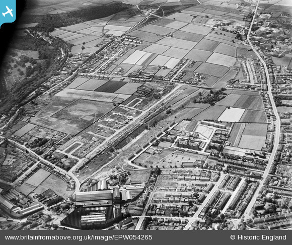
EPW054265 ENGLAND (1937). Crosland Moor and Crosland Hill, Huddersfield, from the north-east, 1937
© Copyright OpenStreetMap contributors and licensed by the OpenStreetMap Foundation. 2026. Cartography is licensed as CC BY-SA.
Nearby Images (5)
EPW054265

EPW022875

EPW022877

EPW022876

EPW022878

Details
| Title | [EPW054265] Crosland Moor and Crosland Hill, Huddersfield, from the north-east, 1937 |
| Reference | EPW054265 |
| Date | 13-July-1937 |
| Link | |
| Place name | HUDDERSFIELD |
| Parish | |
| District | |
| Country | ENGLAND |
| Easting / Northing | 412811, 415402 |
| Longitude / Latitude | -1.8062332916241, 53.634749329631 |
| National Grid Reference | SE128154 |
Pins

RoyPlum |
Thursday 26th of November 2020 12:04:01 AM | |
|
Rose |
Tuesday 11th of February 2020 08:04:44 PM | |
|
Rose |
Tuesday 11th of February 2020 08:01:57 PM | |
|
Rose |
Tuesday 11th of February 2020 07:59:17 PM | |
|
Rose |
Tuesday 11th of February 2020 07:57:53 PM | |
|
Rose |
Tuesday 11th of February 2020 07:57:02 PM | |
|
Rose |
Tuesday 11th of February 2020 07:52:10 PM | |
|
Rose |
Tuesday 11th of February 2020 07:49:44 PM | |
|
Rose |
Tuesday 11th of February 2020 07:48:07 PM | |
|
Rose |
Tuesday 11th of February 2020 07:44:54 PM |