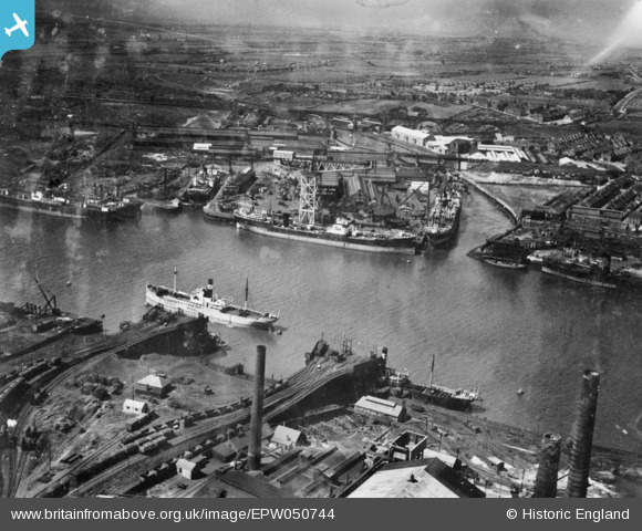
EPW050744 ENGLAND (1936). The Wallsend Slipway and Engineering Co Ltd Shipyard, Wallsend, 1936. This image has been produced from a copy-negative.
    © Copyright OpenStreetMap contributors and licensed by the OpenStreetMap Foundation. 2025. Cartography is licensed as CC BY-SA.
  
Details
| Title | [EPW050744] The Wallsend Slipway and Engineering Co Ltd Shipyard, Wallsend, 1936. This image has been produced from a copy-negative. | 
| Reference | EPW050744 | 
| Date | July-1936 | 
| Link | |
| Place name | WALLSEND | 
| Parish | |
| District | |
| Country | ENGLAND | 
| Easting / Northing | 431830, 566086 | 
| Longitude / Latitude | -1.5025064218019, 54.988273497102 | 
| National Grid Reference | NZ318661 | 
Pins
|  Empty coal wagons run back again by gravity to one of two roads to be re coupled into a train and sent back to their colliery. |   John Wass | Wednesday 28th of January 2015 09:54:44 PM | 
|  Loaded coal wagons run under gravity down the slope to be directed to one of three unloading points. |   John Wass | Wednesday 28th of January 2015 09:52:33 PM | 
 
             
  ![[EPW050744] The Wallsend Slipway and Engineering Co Ltd Shipyard, Wallsend, 1936. This image has been produced from a copy-negative.](http://britainfromabove.org.uk/sites/all/libraries/aerofilms-images/public/100x100/EPW/050/EPW050744.jpg) 
  
                                          ![[EPW053695] The River Tyne between the Wallsend Slipway and Engineering Works and Jarrow Staith, Wallsend, 1937](http://britainfromabove.org.uk/sites/all/libraries/aerofilms-images/public/100x100/EPW/053/EPW053695.jpg) 
 ![[EPW054562] The River Tyne between Wallsend and Hebburn, Wallsend, from the north-east, 1937](http://britainfromabove.org.uk/sites/all/libraries/aerofilms-images/public/100x100/EPW/054/EPW054562.jpg)