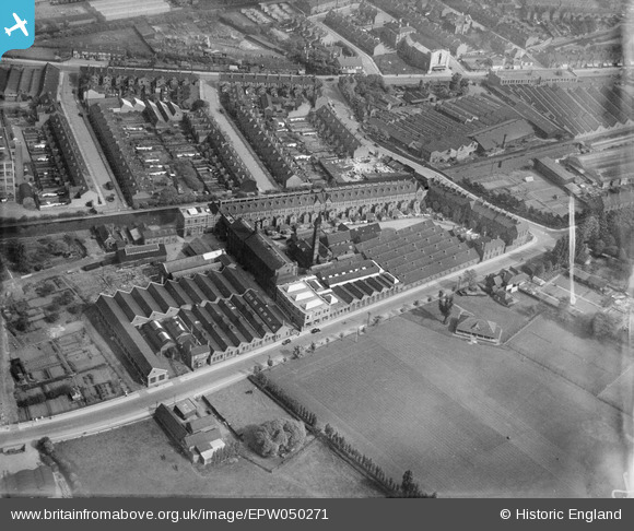
EPW050271 ENGLAND (1936). The Kingfield Textile Works, Coventry, 1936. This image was marked by Aerofilms Ltd for photo editing.
© Copyright OpenStreetMap contributors and licensed by the OpenStreetMap Foundation. 2026. Cartography is licensed as CC BY-SA.
Nearby Images (11)
Details
| Title | [EPW050271] The Kingfield Textile Works, Coventry, 1936. This image was marked by Aerofilms Ltd for photo editing. |
| Reference | EPW050271 |
| Date | May-1936 |
| Link | |
| Place name | COVENTRY |
| Parish | |
| District | |
| Country | ENGLAND |
| Easting / Northing | 433533, 280631 |
| Longitude / Latitude | -1.5068385025422, 52.422263007726 |
| National Grid Reference | SP335806 |
Pins

tezzacov |
Thursday 9th of May 2013 02:10:10 PM | |

tezzacov |
Thursday 9th of May 2013 01:53:42 PM | |

tezzacov |
Thursday 9th of May 2013 01:52:50 PM | |

tezzacov |
Thursday 9th of May 2013 01:52:03 PM | |

tezzacov |
Thursday 9th of May 2013 01:51:13 PM | |

tezzacov |
Thursday 9th of May 2013 01:50:17 PM | |

tezzacov |
Thursday 9th of May 2013 01:48:28 PM | |

tezzacov |
Thursday 9th of May 2013 01:46:54 PM | |

tezzacov |
Thursday 9th of May 2013 01:41:19 PM |


![[EPW050271] The Kingfield Textile Works, Coventry, 1936. This image was marked by Aerofilms Ltd for photo editing.](http://britainfromabove.org.uk/sites/all/libraries/aerofilms-images/public/100x100/EPW/050/EPW050271.jpg)
![[EPW050269] The Kingfield Textile Works, Coventry, 1936](http://britainfromabove.org.uk/sites/all/libraries/aerofilms-images/public/100x100/EPW/050/EPW050269.jpg)
![[EPW050268] The Kingfield Textile Works, Coventry, 1936](http://britainfromabove.org.uk/sites/all/libraries/aerofilms-images/public/100x100/EPW/050/EPW050268.jpg)
![[EPW050265] The Kingfield Textile Works, Coventry, 1936. This image was marked by Aerofilms Ltd for photo editing.](http://britainfromabove.org.uk/sites/all/libraries/aerofilms-images/public/100x100/EPW/050/EPW050265.jpg)
![[EPW050270] The Kingfield Textile Works, Coventry, 1936. This image was marked by Aerofilms Ltd for photo editing.](http://britainfromabove.org.uk/sites/all/libraries/aerofilms-images/public/100x100/EPW/050/EPW050270.jpg)
![[EPW050273] The Kingfield Textile Works, Coventry, 1936](http://britainfromabove.org.uk/sites/all/libraries/aerofilms-images/public/100x100/EPW/050/EPW050273.jpg)
![[EPW050272] The Kingfield Textile Works, Coventry, 1936](http://britainfromabove.org.uk/sites/all/libraries/aerofilms-images/public/100x100/EPW/050/EPW050272.jpg)
![[EPW050267] The Kingfield Textile Works alongside the Coventry Canal, Coventry, 1936](http://britainfromabove.org.uk/sites/all/libraries/aerofilms-images/public/100x100/EPW/050/EPW050267.jpg)
![[EPW050266] The Kingfield Textile Works and the Courtaulds Artificial Silk Works, Coventry, 1936](http://britainfromabove.org.uk/sites/all/libraries/aerofilms-images/public/100x100/EPW/050/EPW050266.jpg)
![[EPW058233] The Daimler Motor Car Works, Radford, from the south-east, 1938](http://britainfromabove.org.uk/sites/all/libraries/aerofilms-images/public/100x100/EPW/058/EPW058233.jpg)
![[EPW020998] Courtaulds Textile Works, Coventry, 1928](http://britainfromabove.org.uk/sites/all/libraries/aerofilms-images/public/100x100/EPW/020/EPW020998.jpg)