
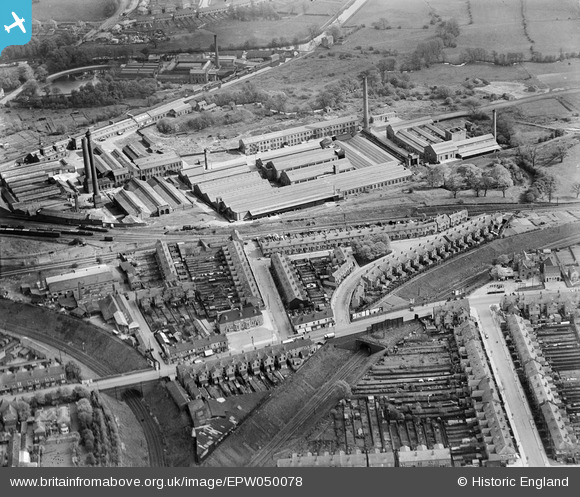
EPW050078 ENGLAND (1936). The Birmingham Factory Centre and housing off Cotteridge Road and Holly Road, King's Norton, 1936
© Copyright OpenStreetMap contributors and licensed by the OpenStreetMap Foundation. 2026. Cartography is licensed as CC BY-SA.
Nearby Images (5)
EPW050078

EPW050079

EPW050080

EPW018368
, Cotteridge Road and environs, Cotteridge, from the north-west, 1927. This image has been produced from a copy-negative.")
EPW018377
, King's Norton, 1927. This image has been produced from a copy-negative.")
Details
| Title | [EPW050078] The Birmingham Factory Centre and housing off Cotteridge Road and Holly Road, King's Norton, 1936 |
| Reference | EPW050078 |
| Date | May-1936 |
| Link | |
| Place name | KING'S NORTON |
| Parish | |
| District | |
| Country | ENGLAND |
| Easting / Northing | 405173, 279799 |
| Longitude / Latitude | -1.9239333548098, 52.415786294118 |
| National Grid Reference | SP052798 |
Pins

pat |
Sunday 3rd of January 2021 04:19:43 PM | |
 Dolman St Store.jpg)
electricar.dv4 |
Monday 17th of July 2017 04:35:10 PM | |
|
fossil |
Monday 7th of April 2014 11:40:33 AM | |
As a lad i use to take papers out in the year 1947-51 john lorton i lived at 86 heathcote road |
fossil |
Monday 7th of April 2014 11:44:42 AM |
|
Rekrap |
Saturday 22nd of March 2014 06:22:31 PM | |
|
Rekrap |
Saturday 22nd of March 2014 06:21:53 PM | |
|
Rekrap |
Saturday 22nd of March 2014 06:21:13 PM | |
|
Rekrap |
Saturday 22nd of March 2014 06:20:40 PM | |
|
Rekrap |
Saturday 22nd of March 2014 06:20:15 PM | |
|
Rekrap |
Saturday 22nd of March 2014 06:19:18 PM | |
|
PURCELL |
Sunday 17th of November 2013 03:25:08 PM | |
|
PURCELL |
Sunday 17th of November 2013 02:56:26 PM | |
|
PURCELL |
Sunday 17th of November 2013 10:05:46 AM | |
|
PURCELL |
Sunday 17th of November 2013 10:05:02 AM | |
|
PURCELL |
Sunday 17th of November 2013 10:04:33 AM | |
|
PURCELL |
Sunday 17th of November 2013 10:04:03 AM | |
|
PURCELL |
Sunday 17th of November 2013 10:01:16 AM | |
|
PURCELL |
Saturday 16th of November 2013 09:01:16 PM | |
|
PURCELL |
Saturday 16th of November 2013 09:00:33 PM | |
|
PURCELL |
Saturday 16th of November 2013 09:00:03 PM | |
|
PURCELL |
Saturday 16th of November 2013 08:59:36 PM | |
|
PURCELL |
Saturday 16th of November 2013 08:59:09 PM |