
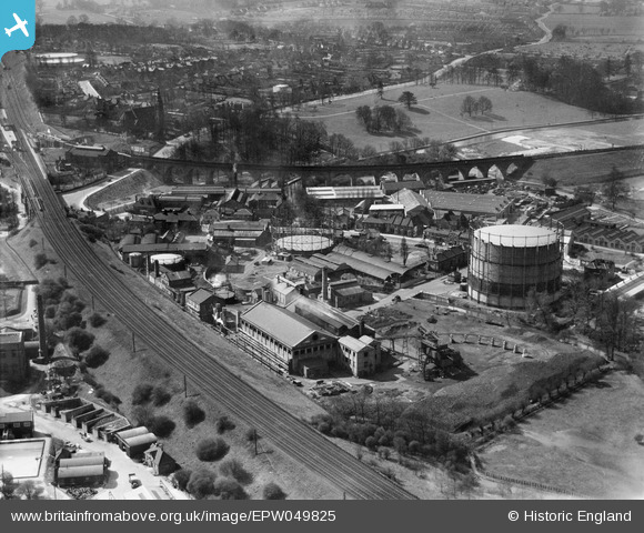
EPW049825 ENGLAND (1936). Gas Works adjacent to the London, Midland & Scottish Railway (LMSR) Bushey Curve and environs, Watford, 1936
© Copyright OpenStreetMap contributors and licensed by the OpenStreetMap Foundation. 2026. Cartography is licensed as CC BY-SA.
Nearby Images (11)
EPW049825
 Bushey Curve and environs, Watford, 1936")
EPW049818
 Bushey Curve, the High Street and environs, Watford, from the south-west, 1936")
EPW049814
 Bushey Curve, the High Street and environs, Watford, from the south-west, 1936")
EPW049823
 Bushey Curve, the High Street and environs, Watford, 1936")
EPW049817
 Bushey Curve, the High Street and environs, Watford, from the south-east, 1936")
EPW049813

EPW060227

EPW049816

EPW049819

EPW021879

EPW049822

Details
| Title | [EPW049825] Gas Works adjacent to the London, Midland & Scottish Railway (LMSR) Bushey Curve and environs, Watford, 1936 |
| Reference | EPW049825 |
| Date | April-1936 |
| Link | |
| Place name | WATFORD |
| Parish | |
| District | |
| Country | ENGLAND |
| Easting / Northing | 511788, 195657 |
| Longitude / Latitude | -0.38407059677919, 51.648114696902 |
| National Grid Reference | TQ118957 |
Pins
 |

Bluid |
Wednesday 7th of October 2020 08:29:47 AM |
|
Brad |
Saturday 13th of October 2018 10:16:32 AM | |
|
Brad |
Saturday 13th of October 2018 10:15:01 AM | |
|
Bluid |
Saturday 1st of October 2016 04:18:54 PM | |
|
Bluid |
Wednesday 6th of January 2016 09:48:22 AM | |
|
Bluid |
Tuesday 17th of June 2014 12:14:10 PM | |

John Swain |
Thursday 19th of September 2013 09:57:05 AM | |
|
John Swain |
Thursday 5th of September 2013 03:56:14 PM | |
|
John Swain |
Thursday 5th of September 2013 03:53:44 PM | |
|
John Swain |
Thursday 5th of September 2013 03:50:37 PM | |
|
John Swain |
Thursday 5th of September 2013 03:39:56 PM | |
|
John Swain |
Thursday 5th of September 2013 03:38:06 PM | |
|
John Swain |
Thursday 5th of September 2013 03:34:52 PM | |
|
John Swain |
Thursday 5th of September 2013 03:31:21 PM | |
|
John Swain |
Thursday 5th of September 2013 03:25:03 PM | |
|
John Swain |
Thursday 5th of September 2013 03:23:53 PM | |
|
John Swain |
Thursday 5th of September 2013 03:22:50 PM | |
|
John Swain |
Thursday 5th of September 2013 03:21:45 PM | |
|
John Swain |
Thursday 5th of September 2013 03:21:02 PM | |
|
John Swain |
Thursday 5th of September 2013 03:20:19 PM | |
|
John Swain |
Thursday 5th of September 2013 03:14:48 PM | |
|
John Swain |
Thursday 5th of September 2013 03:12:55 PM | |
|
John Swain |
Thursday 5th of September 2013 03:09:37 PM | |
|
John Swain |
Thursday 5th of September 2013 03:02:41 PM | |
|
John Swain |
Thursday 5th of September 2013 02:58:22 PM | |
|
John Swain |
Thursday 5th of September 2013 02:56:35 PM | |
|
John Swain |
Thursday 5th of September 2013 02:55:04 PM |


User Comment Contributions
A classic shot of the railway end of the town and the associated industrial activity, concentrated between the original 1837 London-Birmingham Railway and the impressive 1913 viaduct on the Bushey Curve. |
John Swain |
Thursday 5th of September 2013 04:07:37 PM |
|
Watford is listed in 1936 as the sixth wealthiest town in the country, based on the purchasing power of the 65,000 inhabitants. This may not be one of the more salubrious neighbourhoods in the town, but it's worthy of study nevertheless. |
John Swain |
Thursday 5th of September 2013 04:03:12 PM |