
EPW047581 ENGLAND (1935). The Berry Wiggins Oil Refinery and environs, Kingsnorth, from the north-east, 1935

© Copyright OpenStreetMap contributors and licensed by the OpenStreetMap Foundation. 2026. Cartography is licensed as CC BY-SA.
Nearby Images (21)
EPW047581

EAW032071

EAW032069

EAW032067

EAW032066

EPW047583

EAW032068

EPW047579

EPW047578

EAW032065

EPW047586

EPW047584

EAW000060

EPW000060A

EAW000061

EAW032064

EAW000063

EAW000059

EPW047585

EPW000062

EAW000062

Details
| Title | [EPW047581] The Berry Wiggins Oil Refinery and environs, Kingsnorth, from the north-east, 1935 |
| Reference | EPW047581 |
| Date | June-1935 |
| Link | |
| Place name | KINGSNORTH |
| Parish | HOO ST. WERBURGH |
| District | |
| Country | ENGLAND |
| Easting / Northing | 580878, 173269 |
| Longitude / Latitude | 0.60224167486567, 51.429022479499 |
| National Grid Reference | TQ809733 |
Pins
User Comment Contributions
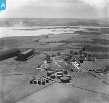
Shows airship hangars |
Lynda Tubbs |
Thursday 10th of July 2014 02:40:27 PM |
old naval airship hangars still in place |

Simonsaorsa |
Tuesday 2nd of July 2013 04:22:00 PM |