
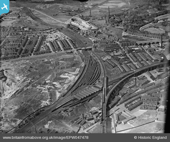
EPW047478 ENGLAND (1935). Cheetham Hill Junction and environs with Kennet House in the distance, Manchester, 1935
© Copyright OpenStreetMap contributors and licensed by the OpenStreetMap Foundation. 2026. Cartography is licensed as CC BY-SA.
Nearby Images (11)
EPW047478

EPW047479

EPW048637

EPW047480

EPW046178

EPW048663

EPW048636

EPW047481

EPW048631

EPW048634

EPW046176

Details
| Title | [EPW047478] Cheetham Hill Junction and environs with Kennet House in the distance, Manchester, 1935 |
| Reference | EPW047478 |
| Date | May-1935 |
| Link | |
| Place name | MANCHESTER |
| Parish | |
| District | |
| Country | ENGLAND |
| Easting / Northing | 385033, 400430 |
| Longitude / Latitude | -2.2256584432746, 53.500104458852 |
| National Grid Reference | SD850004 |
Pins

Barney Rubble |
Monday 23rd of June 2025 02:10:27 PM | |
|
CJ103 |
Friday 25th of October 2019 06:28:41 AM | |
|
John Wass |
Saturday 14th of January 2017 08:40:18 PM | |
This was .Queen Elizabeth House. built in the (rough) shape of an ocean liner. By Barney Rubble. |
Barney Rubble |
Friday 13th of July 2018 10:13:17 PM |
|
John Wass |
Saturday 14th of January 2017 08:38:39 PM | |
|
leekst |
Wednesday 21st of September 2016 05:59:48 PM | |
|
leekst |
Wednesday 21st of September 2016 05:56:16 PM | |
|
Maitland |
Monday 4th of April 2016 09:04:04 PM |