
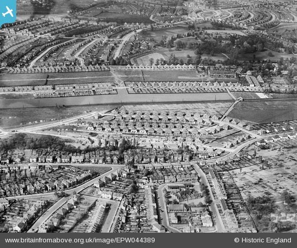
EPW044389 ENGLAND (1934). Housing estates to the north and south of the Southern Railway Dartford Loop Line, Sidcup, 1934
© Copyright OpenStreetMap contributors and licensed by the OpenStreetMap Foundation. 2026. Cartography is licensed as CC BY-SA.
Nearby Images (3)
EPW044389

EPW044392

EPW038219

Details
| Title | [EPW044389] Housing estates to the north and south of the Southern Railway Dartford Loop Line, Sidcup, 1934 |
| Reference | EPW044389 |
| Date | May-1934 |
| Link | |
| Place name | SIDCUP |
| Parish | |
| District | |
| Country | ENGLAND |
| Easting / Northing | 545497, 172666 |
| Longitude / Latitude | 0.093386826129821, 51.433795305138 |
| National Grid Reference | TQ455727 |
Pins

Barney |
Monday 14th of May 2018 02:05:58 PM | |
|
Barney |
Monday 14th of May 2018 02:05:17 PM | |
|
Barney |
Monday 14th of May 2018 02:04:24 PM | |

Paul Wick |
Monday 23rd of January 2017 06:08:49 PM | |
|
Ifor |
Wednesday 23rd of September 2015 08:59:11 PM | |
|
David j |
Friday 14th of November 2014 10:27:05 PM | |
|
David j |
Friday 14th of November 2014 10:25:31 PM | |
|
PeterEm |
Wednesday 15th of October 2014 02:10:30 PM | |
|
PeterEm |
Wednesday 15th of October 2014 02:03:50 PM | |
|
PeterEm |
Wednesday 15th of October 2014 02:03:03 PM | |
|
PeterEm |
Wednesday 15th of October 2014 02:02:22 PM |