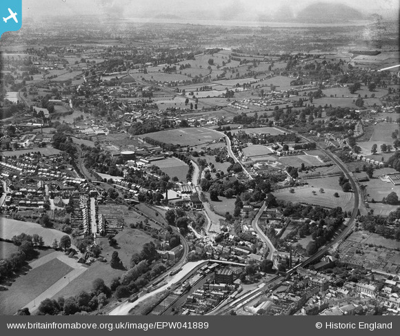
EPW041889 ENGLAND (1933). Cainscross and Stonehouse looking towards the River Severn, Cainscross, from the east, 1933,
© Copyright OpenStreetMap contributors and licensed by the OpenStreetMap Foundation. 2025. Cartography is licensed as CC BY-SA.
Details
| Title | [EPW041889] Cainscross and Stonehouse looking towards the River Severn, Cainscross, from the east, 1933, |
| Reference | EPW041889 |
| Date | June-1933 |
| Link | |
| Place name | CAINSCROSS |
| Parish | STROUD |
| District | |
| Country | ENGLAND |
| Easting / Northing | 384796, 205063 |
| Longitude / Latitude | -2.2202348958988, 51.74360682136 |
| National Grid Reference | SO848051 |
Pins

angus |
Tuesday 10th of October 2017 08:29:48 PM | |

Robert |
Friday 10th of March 2017 02:59:24 PM | |
'Marlin' School |

MR |
Monday 28th of December 2020 05:36:12 PM |

Robert |
Friday 10th of March 2017 12:56:00 PM | |

Robert |
Friday 10th of March 2017 12:08:36 PM | |

Robert |
Friday 10th of March 2017 12:03:57 PM | |

Robert |
Friday 10th of March 2017 12:02:48 PM | |

Robert |
Friday 10th of March 2017 12:01:44 PM | |

Robert |
Friday 10th of March 2017 12:00:08 PM | |

Robert |
Friday 10th of March 2017 11:58:43 AM | |

Robert |
Friday 10th of March 2017 11:57:21 AM | |

Robert |
Friday 10th of March 2017 11:56:27 AM | |

John G. |
Sunday 31st of July 2016 03:28:16 PM | |

Martin |
Wednesday 1st of April 2015 04:22:22 PM | |

gerry-r |
Monday 7th of July 2014 11:21:33 PM | |

gerry-r |
Monday 7th of July 2014 10:49:13 PM |


![[EPW041889] Cainscross and Stonehouse looking towards the River Severn, Cainscross, from the east, 1933,](http://britainfromabove.org.uk/sites/all/libraries/aerofilms-images/public/100x100/EPW/041/EPW041889.jpg)
![[EPW041888] Cainscross and Stonehouse looking towards the River Severn, Cainscross, from the east, 1933,](http://britainfromabove.org.uk/sites/all/libraries/aerofilms-images/public/100x100/EPW/041/EPW041888.jpg)