
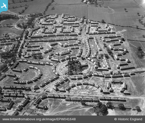
EPW041648 ENGLAND (1933). New housing estate at Haveley Road and Alders Road, Wythenshawe, 1933
© Copyright OpenStreetMap contributors and licensed by the OpenStreetMap Foundation. 2026. Cartography is licensed as CC BY-SA.
Details
| Title | [EPW041648] New housing estate at Haveley Road and Alders Road, Wythenshawe, 1933 |
| Reference | EPW041648 |
| Date | June-1933 |
| Link | |
| Place name | WYTHENSHAWE |
| Parish | |
| District | |
| Country | ENGLAND |
| Easting / Northing | 382264, 388248 |
| Longitude / Latitude | -2.2667195686717, 53.390508925598 |
| National Grid Reference | SJ823882 |
Pins

John Ellis |
Sunday 5th of January 2014 01:12:00 PM | |
|
John Ellis |
Sunday 5th of January 2014 01:11:35 PM | |
|
John Ellis |
Sunday 5th of January 2014 01:10:22 PM | |
|
John Ellis |
Sunday 5th of January 2014 01:09:08 PM | |
|
John Ellis |
Sunday 5th of January 2014 01:07:25 PM | |
|
HOOD |
Tuesday 20th of August 2013 08:35:27 PM | |
Moat Road later build then continued up to the now Gladeside Road (late Greenwood) and Cook's Farm. |
HOOD |
Tuesday 20th of August 2013 08:42:11 PM |
|
HOOD |
Tuesday 20th of August 2013 08:33:26 PM | |
|
HOOD |
Tuesday 20th of August 2013 08:28:18 PM | |
|
HOOD |
Tuesday 20th of August 2013 08:19:03 PM | |
|
HOOD |
Tuesday 20th of August 2013 08:15:28 PM | |
|
HOOD |
Tuesday 20th of August 2013 08:12:52 PM | |
The name of this farm is Haveley Hey. |
John Ellis |
Sunday 5th of January 2014 01:05:48 PM |
|
HOOD |
Tuesday 20th of August 2013 07:49:27 PM | |
|
HOOD |
Tuesday 20th of August 2013 07:46:23 PM | |
|
HOOD |
Tuesday 20th of August 2013 07:40:13 PM | |
|
HOOD |
Tuesday 20th of August 2013 07:23:42 PM | |
The house referred to as a meeting place for the Home Guard at the Rushey Road School entrance was actually the Home Guard Headquarters. The "meeing place" or Drill Hall was in the School Hall. I went on many patrols into the country across Greenwood Rd. looking for parachutists and Germans who had been shot down. |
Samcree |
Tuesday 10th of February 2015 08:27:53 PM |
|
HOOD |
Tuesday 20th of August 2013 07:21:19 PM |
User Comment Contributions

Taken at the same time as the previous two shots, this picture shows the first stages of construction of what became the largest of the pre-war Manchester public housing developments on Wythenshawe estate land. By the outbreak of the war, most of the open country between the Northen Etchells township hamlets of Sharston Green in the north and Brownley Green in the south had been built on. This early development was on land on and adjacent to Lower Haveley Hey, the site of which lies almost exactly under the circle on Haveley Road. At the top of the picture, and with the camera looking almost due south, Haveley Hey (Cook's Farm) is the one relic of the old rural scene still remaining on this shot. This housing estate ultimately got the name of "Benchill", after a large farm of that name (Benchall on very old maps) a couple of fields north-east of Lower Haveley Hey. The countryside in this area before development can be seen - though from a rather higher altitude and on a rather cloudy day - in image EPW017393, taken in April 1927. There's a link to this shot on the left of the image record. |
John Ellis |
Sunday 5th of January 2014 02:19:51 PM |