
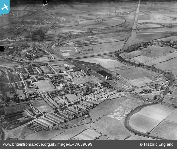
EPW039099 ENGLAND (1932). Agbrigg, Belle Vue and environs, Wakefield, from the south, 1932
© Copyright OpenStreetMap contributors and licensed by the OpenStreetMap Foundation. 2026. Cartography is licensed as CC BY-SA.
Nearby Images (2)
EPW039099

EPW039098

Details
| Title | [EPW039099] Agbrigg, Belle Vue and environs, Wakefield, from the south, 1932 |
| Reference | EPW039099 |
| Date | July-1932 |
| Link | |
| Place name | WAKEFIELD |
| Parish | |
| District | |
| Country | ENGLAND |
| Easting / Northing | 434731, 419645 |
| Longitude / Latitude | -1.4742288992801, 53.671893380854 |
| National Grid Reference | SE347196 |
Pins
sirdouglas |
Friday 16th of May 2014 01:44:19 PM | |
|
sirdouglas |
Friday 16th of May 2014 01:41:31 PM | |
|
sirdouglas |
Friday 16th of May 2014 01:37:32 PM | |

Derekdye |
Monday 14th of January 2013 10:18:14 PM | |
|
Derekdye |
Monday 14th of January 2013 10:16:28 PM | |
|
Derekdye |
Monday 14th of January 2013 10:04:41 PM | |
|
Derekdye |
Monday 14th of January 2013 10:04:05 PM | |
|
Derekdye |
Monday 14th of January 2013 09:53:31 PM | |
Rubgy ? Leauge ? Do you mean Rugby League ? |

gBr |
Wednesday 8th of March 2017 07:22:27 PM |
|
Derekdye |
Monday 14th of January 2013 09:49:06 PM | |
|
Derekdye |
Monday 14th of January 2013 09:47:16 PM | |
|
Derekdye |
Monday 14th of January 2013 09:46:31 PM | |
|
Derekdye |
Monday 14th of January 2013 09:38:19 PM |