
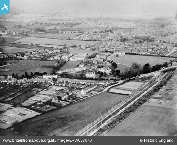
EPW037670 ENGLAND (1932). Taunton School and environs, Taunton, from the south-west, 1932. This image has been produced from a copy-negative.
© Copyright OpenStreetMap contributors and licensed by the OpenStreetMap Foundation. 2026. Cartography is licensed as CC BY-SA.
Nearby Images (2)
EPW037670

EPW027878

Details
| Title | [EPW037670] Taunton School and environs, Taunton, from the south-west, 1932. This image has been produced from a copy-negative. |
| Reference | EPW037670 |
| Date | May-1932 |
| Link | |
| Place name | TAUNTON |
| Parish | |
| District | |
| Country | ENGLAND |
| Easting / Northing | 321596, 125700 |
| Longitude / Latitude | -3.1180674945385, 51.024778296015 |
| National Grid Reference | ST216257 |
Pins

Class31 |
Wednesday 13th of May 2015 07:52:12 AM |
User Comment Contributions
Taunton School, Taunton, 12/05/2015 |
Class31 |
Wednesday 13th of May 2015 05:07:31 PM |
Note the clean ballast of the railway track. This was part of a major work undertaken by the GWR to quadruple [have four running lines] the line between Cogload Junction, where the London Line met the Bristol Line, east of Taunton and Norton Fitwarren to the west. This work was completed on 14th February 1932. Considering the trees still look rather bare, the cleaness of the ballast and lots of railway sleepers still lying at the side of the track I would think this photo was taken shortly after that date rather than the one given (May). |

Nowy Paul |
Sunday 9th of November 2014 06:21:13 PM |