
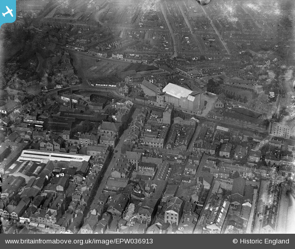
EPW036913 ENGLAND (1931). The Baptist Mission Church at Union Terrace and environs, Chester, 1931
© Copyright OpenStreetMap contributors and licensed by the OpenStreetMap Foundation. 2026. Cartography is licensed as CC BY-SA.
Nearby Images (8)
EPW036913

EPW058011

EPW040167

EAW004377

EPW058007

EPW004007

EPW004006

EPW029883

Details
| Title | [EPW036913] The Baptist Mission Church at Union Terrace and environs, Chester, 1931 |
| Reference | EPW036913 |
| Date | September-1931 |
| Link | |
| Place name | CHESTER |
| Parish | |
| District | |
| Country | ENGLAND |
| Easting / Northing | 340860, 366602 |
| Longitude / Latitude | -2.8852808647767, 53.192925464339 |
| National Grid Reference | SJ409666 |
Pins

Rachel |
Monday 20th of February 2023 01:23:01 PM | |
|
Rachel |
Monday 20th of February 2023 01:21:26 PM | |
|
Karlos |
Saturday 7th of May 2022 03:26:29 AM | |
|
Bunn72 |
Tuesday 9th of June 2015 07:42:54 PM | |
|
Bunn72 |
Tuesday 9th of June 2015 07:41:51 PM | |
|
Bunn72 |
Tuesday 9th of June 2015 07:40:46 PM | |
|
Bunn72 |
Tuesday 9th of June 2015 07:38:29 PM | |
|
Bunn72 |
Tuesday 9th of June 2015 07:37:56 PM | |
|
Bunn72 |
Tuesday 9th of June 2015 07:37:30 PM | |
|
Bunn72 |
Tuesday 9th of June 2015 07:36:17 PM | |
|
Bunn72 |
Tuesday 9th of June 2015 07:35:15 PM | |
|
Bunn72 |
Tuesday 9th of June 2015 07:34:42 PM | |
|
Bunn72 |
Tuesday 9th of June 2015 07:32:52 PM |