
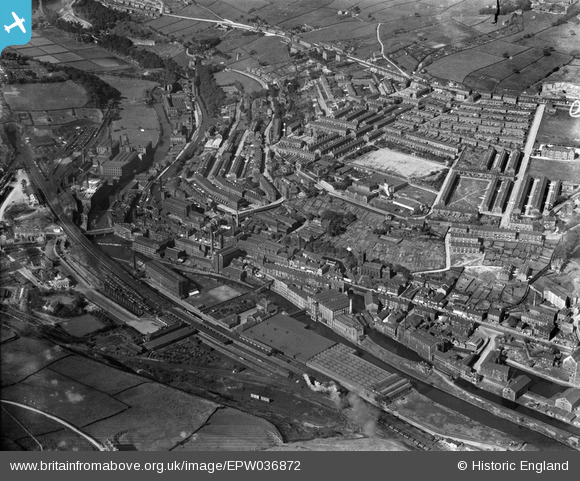
EPW036872 ENGLAND (1931). The town, Sowerby Bridge, 1931
© Copyright OpenStreetMap contributors and licensed by the OpenStreetMap Foundation. 2026. Cartography is licensed as CC BY-SA.
Nearby Images (3)
EPW036872

EPW036871

EPW036870

Details
| Title | [EPW036872] The town, Sowerby Bridge, 1931 |
| Reference | EPW036872 |
| Date | September-1931 |
| Link | |
| Place name | SOWERBY BRIDGE |
| Parish | |
| District | |
| Country | ENGLAND |
| Easting / Northing | 406065, 423710 |
| Longitude / Latitude | -1.9081041224435, 53.709553188164 |
| National Grid Reference | SE061237 |
Pins

Moonraker |
Wednesday 18th of October 2023 05:36:44 PM | |
|
Moonraker |
Wednesday 18th of October 2023 05:09:08 PM | |
|
Moonraker |
Wednesday 18th of October 2023 04:48:44 PM | |
|
RT |
Monday 19th of March 2018 12:35:50 PM | |
|
John W |
Monday 21st of November 2016 08:15:22 PM | |
|
Sooz |
Sunday 14th of June 2015 07:03:36 PM | |
|
Ronrat |
Friday 6th of June 2014 11:00:51 PM | |
|
Toby Clempson |
Tuesday 12th of November 2013 07:32:39 AM | |
|
MB |
Thursday 17th of January 2013 04:28:23 PM | |
|
MB |
Thursday 17th of January 2013 04:28:00 PM | |
|
MB |
Thursday 17th of January 2013 04:26:31 PM | |
|
MB |
Thursday 17th of January 2013 04:25:55 PM | |
|
MB |
Thursday 17th of January 2013 04:24:51 PM | |
|
MB |
Thursday 17th of January 2013 04:24:08 PM | |
|
MB |
Thursday 17th of January 2013 04:23:45 PM | |
|
MB |
Thursday 17th of January 2013 04:22:31 PM | |
|
MB |
Thursday 17th of January 2013 04:21:48 PM | |
|
MB |
Thursday 17th of January 2013 04:20:11 PM | |
This basin is the end of the Calder and Hebble Navigation. |
John W |
Monday 21st of November 2016 08:16:54 PM |
|
MB |
Thursday 17th of January 2013 04:19:32 PM | |
|
MB |
Thursday 17th of January 2013 04:18:23 PM | |
|
MB |
Thursday 17th of January 2013 04:17:58 PM | |
|
MB |
Thursday 17th of January 2013 04:16:43 PM | |
|
MB |
Thursday 17th of January 2013 04:16:07 PM | |
|
MB |
Thursday 17th of January 2013 04:14:58 PM | |
|
MB |
Thursday 17th of January 2013 04:14:30 PM | |
|
MB |
Thursday 17th of January 2013 04:13:32 PM | |
|
MB |
Thursday 17th of January 2013 04:12:35 PM | |
|
MB |
Thursday 17th of January 2013 04:11:54 PM | |
|
MB |
Thursday 17th of January 2013 04:04:07 PM | |
|
MB |
Thursday 17th of January 2013 04:03:21 PM |
User Comment Contributions
View from ground level, seen from above the tunnel portal, extreme left, in 1959 - in jb303's collection on the Flickr site: www.flickr.com/photos/thanoz/5359831354/in/photostream/ |
MB |
Thursday 17th of January 2013 04:06:27 PM |