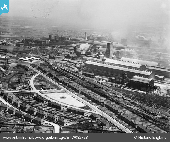
EPW032728 ENGLAND (1930). Roscoe Road and the ICI Synthetic Ammonia Works, Billingham, from the west, 1930
    © Copyright OpenStreetMap contributors and licensed by the OpenStreetMap Foundation. 2025. Cartography is licensed as CC BY-SA.
  
Nearby Images (5)
Details
| Title | [EPW032728] Roscoe Road and the ICI Synthetic Ammonia Works, Billingham, from the west, 1930 | 
| Reference | EPW032728 | 
| Date | July-1930 | 
| Link | |
| Place name | BILLINGHAM | 
| Parish | BILLINGHAM | 
| District | |
| Country | ENGLAND | 
| Easting / Northing | 446273, 522007 | 
| Longitude / Latitude | -1.2838190095068, 54.591010848003 | 
| National Grid Reference | NZ463220 | 
Pins
Be the first to add a comment to this image!
 
             
  ![[EPW032728] Roscoe Road and the ICI Synthetic Ammonia Works, Billingham, from the west, 1930](http://britainfromabove.org.uk/sites/all/libraries/aerofilms-images/public/100x100/EPW/032/EPW032728.jpg) 
  
                                          ![[EPW032183] The ICI Synthethic Ammonia Works, Billingham, 1930](http://britainfromabove.org.uk/sites/all/libraries/aerofilms-images/public/100x100/EPW/032/EPW032183.jpg) 
 ![[EPW032184] The ICI Synthethic Ammonia Works, Billingham, 1930](http://britainfromabove.org.uk/sites/all/libraries/aerofilms-images/public/100x100/EPW/032/EPW032184.jpg) 
 ![[EPW032223] Crescent Avenue and environs, Billingham, 1930](http://britainfromabove.org.uk/sites/all/libraries/aerofilms-images/public/100x100/EPW/032/EPW032223.jpg) 
 ![[EAW024034] Mill Lane and the ICI Synthetic Ammonia Works, Billingham, 1949. This image has been produced from a print.](http://britainfromabove.org.uk/sites/all/libraries/aerofilms-images/public/100x100/EAW/024/EAW024034.jpg)