
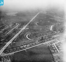
EPW032194 ENGLAND (1930). Central Avenue and environs, Billingham, 1930

© Copyright OpenStreetMap contributors and licensed by the OpenStreetMap Foundation. 2026. Cartography is licensed as CC BY-SA.
Nearby Images (5)
EPW032194

EPW032201

EPW032188

EPW032210

EPW032198

Details
| Title | [EPW032194] Central Avenue and environs, Billingham, 1930 |
| Reference | EPW032194 |
| Date | May-1930 |
| Link | |
| Place name | BILLINGHAM |
| Parish | BILLINGHAM |
| District | |
| Country | ENGLAND |
| Easting / Northing | 445897, 522781 |
| Longitude / Latitude | -1.2895169014245, 54.59800117454 |
| National Grid Reference | NZ459228 |
Pins

Class31 |
Wednesday 7th of November 2012 11:20:56 AM | |
|
Class31 |
Wednesday 7th of November 2012 11:20:25 AM | |
|
Class31 |
Wednesday 7th of November 2012 11:19:50 AM | |
|
Class31 |
Wednesday 7th of November 2012 11:19:15 AM | |
|
Class31 |
Wednesday 7th of November 2012 11:18:45 AM | |
|
Class31 |
Wednesday 7th of November 2012 11:18:15 AM | |
|
Class31 |
Wednesday 7th of November 2012 11:17:49 AM | |
|
Class31 |
Wednesday 7th of November 2012 11:17:08 AM | |
|
Class31 |
Wednesday 7th of November 2012 11:16:53 AM | |
|
Class31 |
Wednesday 7th of November 2012 11:16:34 AM | |
|
Class31 |
Wednesday 7th of November 2012 11:16:18 AM |
User Comment Contributions
Central Avenue and environs, Billingham, 1930 |

Ali |
Sunday 20th of January 2013 09:19:50 PM |