
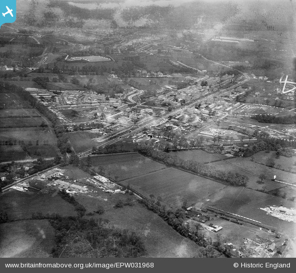
EPW031968 ENGLAND (1930). St Helier and environs, Morden, from the south-east, 1930
© Copyright OpenStreetMap contributors and licensed by the OpenStreetMap Foundation. 2026. Cartography is licensed as CC BY-SA.
Nearby Images (4)
EPW031968

EPW035584

EPW031814

EPW031810

Details
| Title | [EPW031968] St Helier and environs, Morden, from the south-east, 1930 |
| Reference | EPW031968 |
| Date | May-1930 |
| Link | |
| Place name | MORDEN |
| Parish | |
| District | |
| Country | ENGLAND |
| Easting / Northing | 526218, 166581 |
| Longitude / Latitude | -0.18600137388921, 51.383726574698 |
| National Grid Reference | TQ262666 |
Pins

Mark1973 |
Wednesday 17th of April 2019 01:45:57 PM | |
|
Johnners |
Wednesday 11th of June 2014 09:24:35 AM | |
|
Geoff Smith |
Thursday 16th of May 2013 05:47:42 PM | |

Maurice |
Friday 11th of January 2013 08:06:38 AM | |
|
Maurice |
Wednesday 12th of December 2012 10:30:59 PM | |
|
christhewino |
Wednesday 12th of December 2012 09:47:46 PM | |
Yes! It is on the construction railway. I will post more later on this. |
Maurice |
Wednesday 12th of December 2012 10:36:19 PM |

Class31 |
Friday 16th of November 2012 07:12:27 PM | |
|
Class31 |
Friday 16th of November 2012 07:11:30 PM | |
|
Class31 |
Friday 16th of November 2012 07:10:13 PM | |
|
Class31 |
Friday 16th of November 2012 07:09:14 PM | |
|
Class31 |
Friday 16th of November 2012 07:08:28 PM | |
|
Class31 |
Friday 16th of November 2012 07:08:01 PM | |
|
Class31 |
Friday 16th of November 2012 07:06:54 PM |

User Comment Contributions
See EPW035584 for some more detailed annotation of railway lines within the estate. |
Maurice |
Friday 11th of January 2013 08:17:07 AM |
The St. Helier Estate Railway is shown in Joe Brown's authoritative 'London Railway Atlas' as branch from the Wimbledon to Croydon line of the Southern Railway, running south west from sidings between Mitcham and Mitcham Junction. The branch was about one mile long and included a bridge across the River Wandle. It is shown as ending in a triangle with a run-round loop on one side. One suspects this might be 'diagrammatic', the reality being that the estate end of the line was moved around as building progressed to get materials as close as possible to the point of use. The line was open from 1928-1936, being one of the later lines of this type. It is interesting to realise the economics of building private siding connections to such large scale developments as the London County Council's St Helier Estate was favourable compared with transhipment of materials to road haulage or indeed road haulage from the point of origin. This reflected the relatively small size and power of contemporary road vehicles when required to move large amounts of heavy and bulky materials. The lines were as economical as possible with track being directly laid on the ground, most likely using short, second-hand track panels. Other sites around London with railway connections into suburban developments may be seen in the following images. EPW006293 Northwood 1921 EPW006551 Chadwell Heath 1921 - Becontree Estate Railway EPW016517 and EPW017380 Burnt Oak - Edgware 1926 EPW017649 Becontree 1927 |
Maurice |
Friday 11th of January 2013 08:01:30 AM |