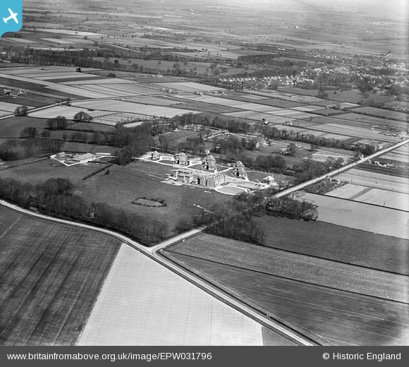
EPW031796 ENGLAND (1930). Hull Sanatorium, Cottingham, 1930

© Copyright OpenStreetMap contributors and licensed by the OpenStreetMap Foundation. 2024. Cartography is licensed as CC BY-SA.

Nearby Images (2)

EPW031796
  0° 0m
EPW031798
  99° 99m

Details

Title [EPW031796] Hull Sanatorium, Cottingham, 1930
Reference EPW031796
Date 30-April-1930
Link
Place name COTTINGHAM
Parish COTTINGHAM
District
Country ENGLAND
Easting / Northing 502612, 432342
Longitude / Latitude -0.44268826443652, 53.777068657688
National Grid Reference TA026323

Pins

Burnt Oak House, Castle road, Cottingham

dd1000
Wednesday 31st of July 2019 11:38:32 AM
Castle Road, showing the ornate gateway entrance to the hospital.

dd1000
Wednesday 31st of July 2019 11:37:34 AM
Burnt Oak Villa on Castle road Cottingham, https://www.google.com/maps/@53.7758413,-0.4372553,127a,35y,45t/data=!3m1!1e3 https://maps.nls.uk/geo/explore/side-by-side/#zoom=17&lat=53.7773&lon=-0.4381&layers=6&right=BingHyb

dd1000
Tuesday 30th of July 2019 04:47:57 PM
The watch tower at Castle Hill built in 1815, Once formed part of Cottingham Castle which was was destroyed in a fire in 1861, the 100 acre estate was eventually bought by Hull Corporation in 1911 with the intention of building a hospital for treating patients with infectious diseases, the clean air on the hill overlooking Cottingham was regarded as an attractive place for recuperation and recovery. Today the tower still lies within the grounds of Castle Hill hospital but, cloaked behind tall trees, it's hard to spot. https://maps.nls.uk/geo/explore/side-by-side/#zoom=17&lat=53.7767&lon=-0.4483&layers=6&right=BingHyb

dd1000
Tuesday 30th of July 2019 04:40:45 PM
Cottingham which was and may still be the largest village in England.

John Wass
Tuesday 11th of November 2014 03:41:56 PM
The actual "castle" at the top of the hill which gave the hospital it's name.

John Wass
Tuesday 11th of November 2014 03:40:36 PM