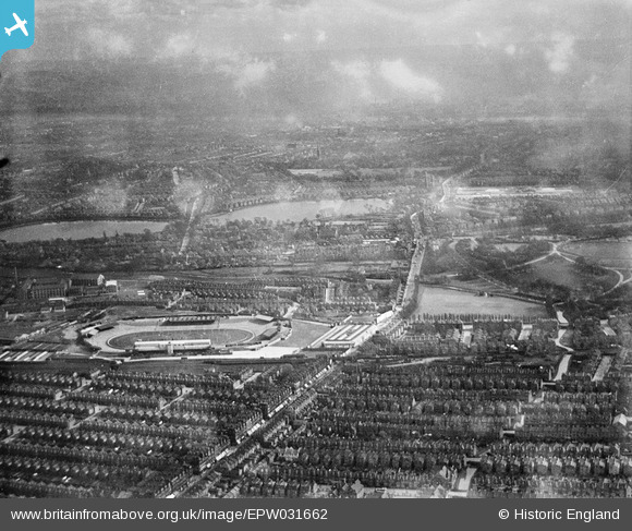
EPW031662 ENGLAND (1930). Harringay Stadium and Green Lanes, Harringay, from the north-west, 1930
    © Copyright OpenStreetMap contributors and licensed by the OpenStreetMap Foundation. 2025. Cartography is licensed as CC BY-SA.
  
Nearby Images (6)
Details
| Title | [EPW031662] Harringay Stadium and Green Lanes, Harringay, from the north-west, 1930 | 
| Reference | EPW031662 | 
| Date | May-1930 | 
| Link | |
| Place name | HARRINGAY | 
| Parish | |
| District | |
| Country | ENGLAND | 
| Easting / Northing | 531826, 188293 | 
| Longitude / Latitude | -0.097344513748774, 51.577590258734 | 
| National Grid Reference | TQ318883 | 
Pins
|  Endymion Road, N4 |   billyfern | Monday 30th of June 2014 12:24:57 AM | 
|  Manor House, Green Lanes & Seven Sisters Road, N4 |   billyfern | Monday 30th of June 2014 12:23:31 AM | 
|  Finsbury Park, N4 |   billyfern | Monday 30th of June 2014 12:23:02 AM | 
|  Mattison Road | Class31 | Wednesday 13th of February 2013 04:41:26 PM | 
|  Duckett Road | Class31 | Wednesday 13th of February 2013 04:40:57 PM | 
|  Cavendish Road | Class31 | Wednesday 13th of February 2013 04:40:21 PM | 
|  Burgoyne Road | Class31 | Wednesday 13th of February 2013 04:39:39 PM | 
|  Umfreville Road | Class31 | Wednesday 13th of February 2013 04:39:11 PM | 
|  Harringay Stadium was a major greyhound racing and motorcycle speedway venue in Harringay, North London. It was built and opened in 1927 and closed in 1987. | Class31 | Wednesday 13th of February 2013 04:32:52 PM | 
|  West Reservoir | Class31 | Wednesday 13th of February 2013 04:31:05 PM | 
|  East Reservoir | Class31 | Wednesday 13th of February 2013 04:30:50 PM | 
|  Green Lanes | Class31 | Wednesday 13th of February 2013 04:30:12 PM | 
 
             
  ![[EPW031662] Harringay Stadium and Green Lanes, Harringay, from the north-west, 1930](http://britainfromabove.org.uk/sites/all/libraries/aerofilms-images/public/100x100/EPW/031/EPW031662.jpg) 
  
                                          ![[EPW031502] St Paul's Church and terraced housing surrounding Burgoyne Road, Umfreville Road and Cavendish Road, Harringay, 1930](http://britainfromabove.org.uk/sites/all/libraries/aerofilms-images/public/100x100/EPW/031/EPW031502.jpg) 
 ![[EPW056659] Harringay Greyhound and Motor Cycle Stadium, Harringay, 1938](http://britainfromabove.org.uk/sites/all/libraries/aerofilms-images/public/100x100/EPW/056/EPW056659.jpg) 
 ![[EPW056660] Harringay Greyhound and Motor Cycle Stadium, Harringay, 1938](http://britainfromabove.org.uk/sites/all/libraries/aerofilms-images/public/100x100/EPW/056/EPW056660.jpg) 
 ![[EAW008755] The Harringay Arena and Stadium, Harringay, 1947. This image has been produced from a damaged negative.](http://britainfromabove.org.uk/sites/all/libraries/aerofilms-images/public/100x100/EAW/008/EAW008755.jpg) 
 ![[EAW008756] The Harringay Arena and Stadium, Harringay, 1947](http://britainfromabove.org.uk/sites/all/libraries/aerofilms-images/public/100x100/EAW/008/EAW008756.jpg)