
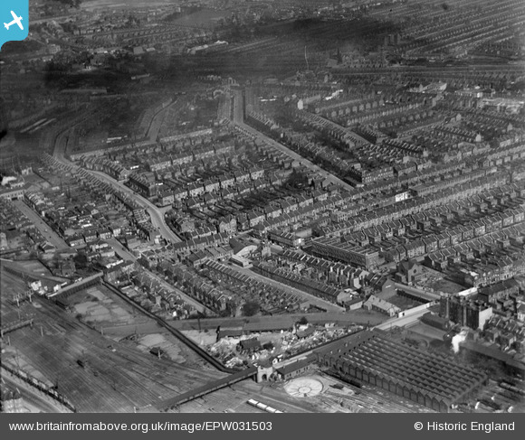
EPW031503 ENGLAND (1930). Terraced housing surrounding Turnpike Lane and Alexandra Road, Harringay, 1930
© Copyright OpenStreetMap contributors and licensed by the OpenStreetMap Foundation. 2026. Cartography is licensed as CC BY-SA.
Nearby Images (3)
EPW031503

EPW051503

EPW007401

Details
| Title | [EPW031503] Terraced housing surrounding Turnpike Lane and Alexandra Road, Harringay, 1930 |
| Reference | EPW031503 |
| Date | February-1930 |
| Link | |
| Place name | HARRINGAY |
| Parish | |
| District | |
| Country | ENGLAND |
| Easting / Northing | 531061, 189517 |
| Longitude / Latitude | -0.10792233440949, 51.588769346244 |
| National Grid Reference | TQ311895 |
Pins

MB |
Wednesday 29th of January 2014 10:16:59 AM | |
|
MB |
Wednesday 29th of January 2014 10:15:46 AM | |
|
MB |
Wednesday 29th of January 2014 10:15:17 AM | |
|
MB |
Wednesday 29th of January 2014 10:14:52 AM | |

Class31 |
Wednesday 13th of February 2013 03:20:43 PM | |
|
Class31 |
Wednesday 13th of February 2013 03:20:11 PM | |
|
Class31 |
Wednesday 13th of February 2013 03:19:48 PM | |
|
Class31 |
Wednesday 13th of February 2013 03:19:26 PM | |
|
Class31 |
Wednesday 13th of February 2013 03:18:56 PM | |
|
Class31 |
Wednesday 13th of February 2013 03:18:23 PM | |
|
Class31 |
Wednesday 13th of February 2013 03:16:55 PM | |
|
Class31 |
Wednesday 13th of February 2013 03:16:17 PM | |
|
Class31 |
Wednesday 13th of February 2013 03:07:52 PM | |
|
Class31 |
Wednesday 13th of February 2013 03:07:23 PM |
User Comment Contributions
View looking north. |
Class31 |
Wednesday 5th of March 2014 04:04:17 PM |