
EPW029094 ENGLAND (1929). The Cleveland Steel Works and environs, Guisborough, 1929

© Copyright OpenStreetMap contributors and licensed by the OpenStreetMap Foundation. 2026. Cartography is licensed as CC BY-SA.
Nearby Images (2)
EPW029094

EPW038957

Details
| Title | [EPW029094] The Cleveland Steel Works and environs, Guisborough, 1929 |
| Reference | EPW029094 |
| Date | 12-September-1929 |
| Link | |
| Place name | GUISBOROUGH |
| Parish | GUISBOROUGH |
| District | |
| Country | ENGLAND |
| Easting / Northing | 461310, 515707 |
| Longitude / Latitude | -1.0524316773669, 54.532794531567 |
| National Grid Reference | NZ613157 |
Pins

Class31 |
Sunday 21st of October 2012 07:20:47 PM | |
|
Class31 |
Sunday 21st of October 2012 07:19:56 PM | |
|
Class31 |
Sunday 21st of October 2012 06:33:54 PM | |
|
Class31 |
Sunday 21st of October 2012 06:33:01 PM | |
|
Class31 |
Sunday 21st of October 2012 06:32:02 PM |
User Comment Contributions
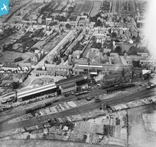
Westgate runs across the picture about quarter of the way down. |

Ali |
Friday 19th of October 2012 06:12:09 PM |