Downtime message
Due to planned maintenance taking place on Thursday 9th October between 9:00 AM and 1:00 PM, services might be disrupted or temporarily unavailable. We apologise for any inconvenience.
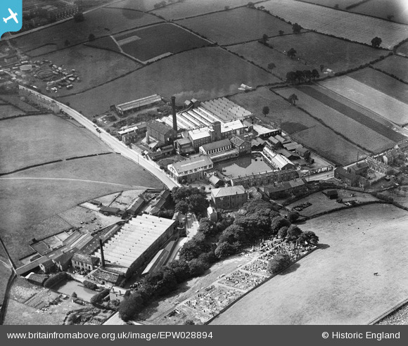
EPW028894 ENGLAND (1929). Springfield Worsted Mill, Bank Bottom Woollen Mill and the Farsley Baptist Burial Ground, Farsley Beck Bottom, 1929
© Copyright OpenStreetMap contributors and licensed by the OpenStreetMap Foundation. 2025. Cartography is licensed as CC BY-SA.
Nearby Images (11)
Details
| Title | [EPW028894] Springfield Worsted Mill, Bank Bottom Woollen Mill and the Farsley Baptist Burial Ground, Farsley Beck Bottom, 1929 |
| Reference | EPW028894 |
| Date | August-1929 |
| Link | |
| Place name | FARSLEY BECK BOTTOM |
| Parish | |
| District | |
| Country | ENGLAND |
| Easting / Northing | 422190, 435670 |
| Longitude / Latitude | -1.6629238487792, 53.816624071598 |
| National Grid Reference | SE222357 |
Pins
Be the first to add a comment to this image!


![[EPW028894] Springfield Worsted Mill, Bank Bottom Woollen Mill and the Farsley Baptist Burial Ground, Farsley Beck Bottom, 1929](http://britainfromabove.org.uk/sites/all/libraries/aerofilms-images/public/100x100/EPW/028/EPW028894.jpg)
![[EPW028892] Springfield Worsted Mill, Bank Bottom Woollen Mill and the Farsley Baptist Burial Ground, Farsley Beck Bottom, 1929](http://britainfromabove.org.uk/sites/all/libraries/aerofilms-images/public/100x100/EPW/028/EPW028892.jpg)
![[EPW028891] Springfield Worsted Mill and Bank Bottom Woollen Mill, Farsley Beck Bottom, 1929](http://britainfromabove.org.uk/sites/all/libraries/aerofilms-images/public/100x100/EPW/028/EPW028891.jpg)
![[EPW028895] Springfield Worsted Mill and Bank Bottom Woollen Mill, Farsley Beck Bottom, 1929](http://britainfromabove.org.uk/sites/all/libraries/aerofilms-images/public/100x100/EPW/028/EPW028895.jpg)
![[EPW028893] Springfield Worsted Mill and Bank Bottom Woollen Mill, Farsley Beck Bottom, 1929](http://britainfromabove.org.uk/sites/all/libraries/aerofilms-images/public/100x100/EPW/028/EPW028893.jpg)
![[EPW028889] Springfield Worsted Mill and Bagley Lane, Farsley Beck Bottom, 1929](http://britainfromabove.org.uk/sites/all/libraries/aerofilms-images/public/100x100/EPW/028/EPW028889.jpg)
![[EPW028890] Springfield Worsted Mill and Bagley Lane, Farsley Beck Bottom, 1929](http://britainfromabove.org.uk/sites/all/libraries/aerofilms-images/public/100x100/EPW/028/EPW028890.jpg)
![[EPW055890] Sunlight breaking over Farsley, Farsley Beck Bottom, from the north-east, 1937](http://britainfromabove.org.uk/sites/all/libraries/aerofilms-images/public/100x100/EPW/055/EPW055890.jpg)
![[EPW028896] Broom Woollen Mill and Cape Woollen Mill, Farsley Beck Bottom, 1929](http://britainfromabove.org.uk/sites/all/libraries/aerofilms-images/public/100x100/EPW/028/EPW028896.jpg)
![[EPW028901] Cape, Broom and Bank Bottom Woollen Mills and Springfield Worsted Mill, Farsley Beck Bottom, 1929](http://britainfromabove.org.uk/sites/all/libraries/aerofilms-images/public/100x100/EPW/028/EPW028901.jpg)
![[EPW028899] Broom Woollen Mill and Cape Woollen Mill, Farsley Beck Bottom, 1929](http://britainfromabove.org.uk/sites/all/libraries/aerofilms-images/public/100x100/EPW/028/EPW028899.jpg)