
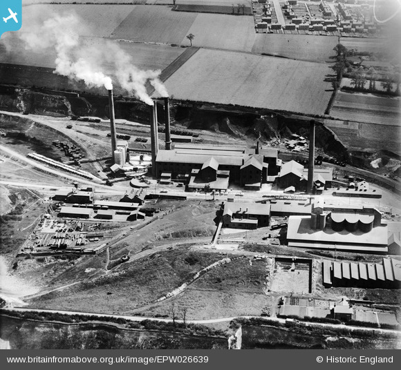
EPW026639 ENGLAND (1929). The Tunnel Portland Cement Works, West Thurrock, 1929
© Copyright OpenStreetMap contributors and licensed by the OpenStreetMap Foundation. 2026. Cartography is licensed as CC BY-SA.
Nearby Images (34)
EPW026639

EPW032826

EPW046466

EPW057044

EPW032825

EPW039476

EPW046462

EPW039470

EPW057047

EPW026640

EPW039471

EPW046467

EPW039475

EPW046464

EPW057055

EPW057050

EPW046468

EPW039473

EPW057046

EPW057052

EPW057054

EPW026644

EPW057043

EPW039472

EPW057051

EPW057048

EPW057053

EPW039474

EPW046469

EPW046470

EPW046463

EPW057045

EPW057049

EPW046465

Details
| Title | [EPW026639] The Tunnel Portland Cement Works, West Thurrock, 1929 |
| Reference | EPW026639 |
| Date | May-1929 |
| Link | |
| Place name | WEST THURROCK |
| Parish | |
| District | |
| Country | ENGLAND |
| Easting / Northing | 557668, 177953 |
| Longitude / Latitude | 0.2707162898094, 51.478045233798 |
| National Grid Reference | TQ577780 |
Pins

Dylan Moore |
Thursday 18th of October 2012 09:39:59 AM | |
|
Dylan Moore |
Thursday 18th of October 2012 09:39:21 AM | |
|
Dylan Moore |
Thursday 18th of October 2012 09:38:23 AM | |
|
Dylan Moore |
Thursday 18th of October 2012 09:37:47 AM | |
|
Dylan Moore |
Thursday 18th of October 2012 09:36:49 AM | |
|
Dylan Moore |
Thursday 18th of October 2012 09:36:19 AM | |
|
Dylan Moore |
Thursday 18th of October 2012 09:35:41 AM |
User Comment Contributions
The West Thurrock Plant of the Tunnel Portland Cement Company Ltd. The Tunnel name was derived from Tunnel Farm, which still stood at this time, on the top of the quarry face off-frame to the left. The plant began in a small way in 1874, but became much more significant when it was acquired by the Danish firm F L Smidth in 1911, when it was rebuilt on up-to-date lines and rapidly expanded. By the time of the photograph, the plant was in a period of transition, with many new features at the planning stage. The original two rotary kilns had increased to four, and a further three were installed before WWII. By 1938 it was the largest British plant, and remained so until 1970. It closed in 1976. This gives a good view of the rear of the newly-installed Kiln 4, which was a new departure in kiln design, with long spans between tyres. It was similar in design to the kilns installed at the time at Hope and at Ketton. The clinker stockpile can be seen: it has spilled over onto disused rail tracks in the foreground. The gantry that originally conveyed clinker across the rail tracks has been taken down, and shortly after this, the stockpile and the area to the left was turned into a large stockyard with overhead cranes. Successive cement mills were then installed in the left foreground. The power house was already out of use, the plant having been connected to the Barking electricity distribution system: grid supply was not yet operational. Trains of chalk wagons can be seen lined up, brought from the quarry to the left for feeding to the washmills. Until 1927, the clay had been brought up from the wharf to the right, but now clay was fed to the washmills in slurry form from one of the mixer tanks. The slurry was made at Aveley, and pumped 2.3 km to the plant. |
Dylan Moore |
Thursday 18th of October 2012 09:59:45 AM |