
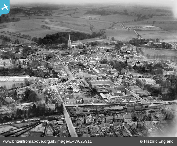
EPW025911 ENGLAND (1929). The town, Saffron Walden, from the south, 1929
© Copyright OpenStreetMap contributors and licensed by the OpenStreetMap Foundation. 2026. Cartography is licensed as CC BY-SA.
Nearby Images (5)
EPW025911

EPW025916

EPW025912

EPW025909

EPW025910

Details
| Title | [EPW025911] The town, Saffron Walden, from the south, 1929 |
| Reference | EPW025911 |
| Date | 3-April-1929 |
| Link | |
| Place name | SAFFRON WALDEN |
| Parish | SAFFRON WALDEN |
| District | |
| Country | ENGLAND |
| Easting / Northing | 553879, 238105 |
| Longitude / Latitude | 0.24281476981382, 52.019573210153 |
| National Grid Reference | TL539381 |
Pins

Ray Flack |
Friday 23rd of January 2015 12:56:49 PM | |
|
Ray Flack |
Friday 23rd of January 2015 12:54:22 PM | |
|
Ray Flack |
Friday 23rd of January 2015 12:50:14 PM | |
|
Ray Flack |
Friday 23rd of January 2015 12:49:25 PM | |
|
Ray Flack |
Friday 23rd of January 2015 12:48:08 PM | |
|
Ray Flack |
Friday 23rd of January 2015 12:10:17 PM | |
|
Ray Flack |
Friday 23rd of January 2015 12:09:14 PM | |
|
Ray Flack |
Friday 23rd of January 2015 12:01:39 PM | |
|
Ray Flack |
Friday 23rd of January 2015 11:41:13 AM | |
|
Ray Flack |
Friday 23rd of January 2015 11:30:01 AM | |
|
Ray Flack |
Friday 23rd of January 2015 11:29:21 AM | |
|
Ray Flack |
Friday 23rd of January 2015 11:28:18 AM | |
|
Ray Flack |
Friday 23rd of January 2015 11:26:26 AM |


