
EPW024180 ENGLAND (1928). The village including the railway station and ferry landing stage, Kingswear, 1928

© Copyright OpenStreetMap contributors and licensed by the OpenStreetMap Foundation. 2026. Cartography is licensed as CC BY-SA.
Nearby Images (2)
EPW024180

EPW024212

Details
| Title | [EPW024180] The village including the railway station and ferry landing stage, Kingswear, 1928 |
| Reference | EPW024180 |
| Date | September-1928 |
| Link | |
| Place name | KINGSWEAR |
| Parish | KINGSWEAR |
| District | |
| Country | ENGLAND |
| Easting / Northing | 288180, 51003 |
| Longitude / Latitude | -3.5718209022166, 50.347698156512 |
| National Grid Reference | SX882510 |
Pins

cidge |
Thursday 7th of December 2017 03:42:34 PM | |
|
cidge |
Thursday 7th of December 2017 03:40:32 PM | |
|
cidge |
Thursday 7th of December 2017 03:37:11 PM | |
|
cidge |
Thursday 7th of December 2017 10:34:48 AM | |

MB |
Sunday 7th of October 2012 09:00:49 AM |
User Comment Contributions
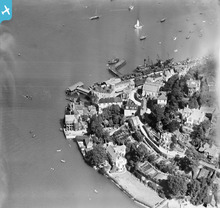
Kingswear Railway Station with Dartmouth Ferry pontoon, Royal Dart Hotel and Eclair Pier. Note the bogie coal wagons. |

Alexander Seal |
Friday 6th of July 2012 06:21:27 PM |