
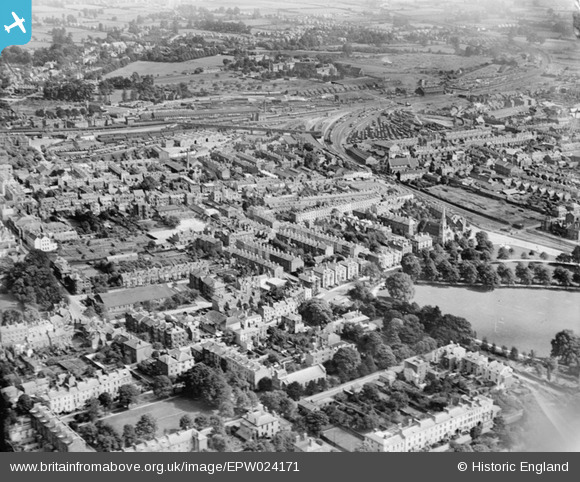
EPW024171 ENGLAND (1928). The area between Park Road and the railway station, Gloucester, 1928
© Copyright OpenStreetMap contributors and licensed by the OpenStreetMap Foundation. 2026. Cartography is licensed as CC BY-SA.
Nearby Images (10)
EPW024171

EPW041490

EPW050779

EPW050782

EPW050781

EPW050780

EPW050777

EAW018731

EPW050784

EPW050783

Details
| Title | [EPW024171] The area between Park Road and the railway station, Gloucester, 1928 |
| Reference | EPW024171 |
| Date | September-1928 |
| Link | |
| Place name | GLOUCESTER |
| Parish | |
| District | |
| Country | ENGLAND |
| Easting / Northing | 383258, 218075 |
| Longitude / Latitude | -2.2431417052792, 51.860566385434 |
| National Grid Reference | SO833181 |
Pins

MB |
Monday 2nd of December 2013 12:57:06 PM | |

Class31 |
Tuesday 16th of October 2012 02:29:49 PM | |
|
Class31 |
Tuesday 16th of October 2012 02:28:28 PM | |
|
Class31 |
Tuesday 16th of October 2012 02:26:46 PM | |
|
Toby Clempson |
Monday 27th of August 2012 10:37:19 AM | |
|
Class31 |
Wednesday 4th of July 2012 10:17:41 PM | |
|
Class31 |
Wednesday 4th of July 2012 10:15:55 PM | |
|
Class31 |
Wednesday 4th of July 2012 10:12:33 PM | |
|
Class31 |
Wednesday 4th of July 2012 10:08:30 PM | |
|
Class31 |
Wednesday 4th of July 2012 10:07:18 PM | |
|
Class31 |
Wednesday 4th of July 2012 10:05:25 PM |
User Comment Contributions
The square in the bottom left-hand corner is Brunswick Square. Beaufort Buildings (Spa Road) can be seen in the bottom right-hand corner, with Spa Villas (Montpellier) just above them. The long building just up from the bottom and in the middle is Christ Church, Brunswick Road. It has a lot of trees in its graveyard. (Only the yews remain in 2012). Part of Gloucester Park can be seen on the right-hand side of the picture. Cromwell Street and Wellington Street take up the centre area of the photograph. |
Kay Powell |
Friday 29th of June 2012 06:11:57 PM |