
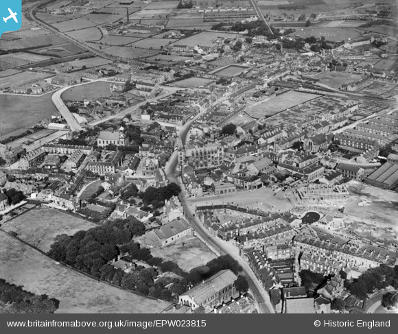
EPW023815 ENGLAND (1928). Lowtown and environs, Pudsey, 1928
© Copyright OpenStreetMap contributors and licensed by the OpenStreetMap Foundation. 2026. Cartography is licensed as CC BY-SA.
Nearby Images (5)
EPW023815

EPW023817

EPW034278

EPW034280

EPW034284

Details
| Title | [EPW023815] Lowtown and environs, Pudsey, 1928 |
| Reference | EPW023815 |
| Date | September-1928 |
| Link | |
| Place name | PUDSEY |
| Parish | |
| District | |
| Country | ENGLAND |
| Easting / Northing | 422325, 433418 |
| Longitude / Latitude | -1.6610365026835, 53.796375417929 |
| National Grid Reference | SE223334 |
Pins

AndrewK |
Thursday 1st of May 2025 01:22:29 PM | |
|
James |
Tuesday 2nd of May 2023 10:28:07 AM | |
|
James |
Tuesday 2nd of May 2023 10:26:47 AM | |
|
James |
Thursday 22nd of December 2022 07:06:25 AM | |
|
James |
Thursday 22nd of December 2022 07:06:10 AM | |
|
James |
Thursday 22nd of December 2022 07:05:42 AM | |
|
James |
Tuesday 9th of August 2022 09:09:10 AM | |
|
Mekbots |
Tuesday 22nd of September 2020 04:50:26 PM | |
|
Tony Avensis |
Thursday 1st of May 2014 01:28:04 PM | |
|
Tony Avensis |
Thursday 1st of May 2014 01:19:13 PM | |
|
Mike Harrison |
Monday 2nd of July 2012 10:13:48 AM | |
|
Mike Harrison |
Sunday 1st of July 2012 08:04:40 PM | |
|
Mike Harrison |
Sunday 1st of July 2012 08:04:15 PM |