
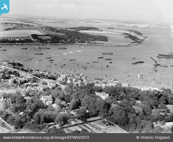
EPW023372 ENGLAND (1928). The Inner Harbour, Falmouth, from the south-west, 1928
© Copyright OpenStreetMap contributors and licensed by the OpenStreetMap Foundation. 2026. Cartography is licensed as CC BY-SA.
Nearby Images (2)
EPW023372

EPW023178

Details
| Title | [EPW023372] The Inner Harbour, Falmouth, from the south-west, 1928 |
| Reference | EPW023372 |
| Date | September-1928 |
| Link | |
| Place name | FALMOUTH |
| Parish | FALMOUTH |
| District | |
| Country | ENGLAND |
| Easting / Northing | 180966, 32290 |
| Longitude / Latitude | -5.0663437259946, 50.149518355588 |
| National Grid Reference | SW810323 |
Pins

matthewfox |
Wednesday 17th of January 2024 09:17:03 PM | |
|
matthewfox |
Wednesday 17th of January 2024 09:15:09 PM | |
|
matthewfox |
Wednesday 17th of January 2024 09:14:32 PM | |
|
matthewfox |
Wednesday 17th of January 2024 09:10:21 PM | |
|
matthewfox |
Wednesday 17th of January 2024 09:09:32 PM | |
|
matthewfox |
Wednesday 17th of January 2024 08:55:13 PM | |
|
matthewfox |
Wednesday 17th of January 2024 08:54:48 PM | |
|
matthewfox |
Wednesday 17th of January 2024 08:51:10 PM | |
|
matthewfox |
Wednesday 17th of January 2024 08:49:35 PM | |
|
matthewfox |
Wednesday 17th of January 2024 08:48:26 PM | |
|
matthewfox |
Wednesday 17th of January 2024 08:47:56 PM | |
|
Tony Piper |
Saturday 15th of June 2013 05:26:37 PM | |
|
Bob Fraser |
Monday 23rd of July 2012 12:21:21 PM | |
|
Bob Fraser |
Monday 23rd of July 2012 12:20:48 PM |