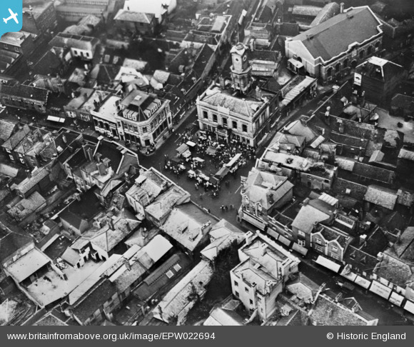
EPW022694 ENGLAND (1928). The Town Hall and Market Place, Basingstoke, 1928. This image has been produced from a copy-negative.
© Copyright OpenStreetMap contributors and licensed by the OpenStreetMap Foundation. 2026. Cartography is licensed as CC BY-SA.
Nearby Images (8)
Details
| Title | [EPW022694] The Town Hall and Market Place, Basingstoke, 1928. This image has been produced from a copy-negative. |
| Reference | EPW022694 |
| Date | August-1928 |
| Link | |
| Place name | BASINGSTOKE |
| Parish | |
| District | |
| Country | ENGLAND |
| Easting / Northing | 463794, 151885 |
| Longitude / Latitude | -1.0856041239042, 51.26203907198 |
| National Grid Reference | SU638519 |
Pins
Be the first to add a comment to this image!


![[EPW022694] The Town Hall and Market Place, Basingstoke, 1928. This image has been produced from a copy-negative.](http://britainfromabove.org.uk/sites/all/libraries/aerofilms-images/public/100x100/EPW/022/EPW022694.jpg)
![[EPW022758] The Market Place, Basingstoke, 1928. This image has been produced from a print.](http://britainfromabove.org.uk/sites/all/libraries/aerofilms-images/public/100x100/EPW/022/EPW022758.jpg)
![[EPW011142] The town centre, Basingstoke, 1924. This image has been produced from a print.](http://britainfromabove.org.uk/sites/all/libraries/aerofilms-images/public/100x100/EPW/011/EPW011142.jpg)
![[EPW011141] London Street and the town centre, Basingstoke, 1924. This image has been produced from a copy-negative.](http://britainfromabove.org.uk/sites/all/libraries/aerofilms-images/public/100x100/EPW/011/EPW011141.jpg)
![[EPW033383] The Market Place, London Street and the War Memorial Park, Basingstoke, 1930](http://britainfromabove.org.uk/sites/all/libraries/aerofilms-images/public/100x100/EPW/033/EPW033383.jpg)
![[EPW022760] The junction of New Street and Winchester Street, Basingstoke, 1928](http://britainfromabove.org.uk/sites/all/libraries/aerofilms-images/public/100x100/EPW/022/EPW022760.jpg)
![[EPW022754] The junction of Winchester Road and Sarum HIll and environs, Basingstoke, 1928. This image has been produced from a print.](http://britainfromabove.org.uk/sites/all/libraries/aerofilms-images/public/100x100/EPW/022/EPW022754.jpg)
![[EPW033379] The town, Basingstoke, 1930. This image has been produced from a copy-negative.](http://britainfromabove.org.uk/sites/all/libraries/aerofilms-images/public/100x100/EPW/033/EPW033379.jpg)