
EPW022540 ENGLAND (1928). Cowley St John, Oxford, 1928

© Copyright OpenStreetMap contributors and licensed by the OpenStreetMap Foundation. 2026. Cartography is licensed as CC BY-SA.
Nearby Images (2)
EPW022540

EAW003931

Details
| Title | [EPW022540] Cowley St John, Oxford, 1928 |
| Reference | EPW022540 |
| Date | 11-August-1928 |
| Link | |
| Place name | OXFORD |
| Parish | |
| District | |
| Country | ENGLAND |
| Easting / Northing | 452733, 205622 |
| Longitude / Latitude | -1.2360940950958, 51.746357379806 |
| National Grid Reference | SP527056 |
Pins

RLY |
Tuesday 29th of December 2020 04:35:14 PM | |
|
RLY |
Tuesday 29th of December 2020 04:34:52 PM | |
|
RLY |
Tuesday 29th of December 2020 04:34:19 PM | |
|
RLY |
Tuesday 29th of December 2020 04:33:22 PM | |
|
Roger Harvey |
Monday 4th of September 2017 06:31:13 PM | |
|
Roger Harvey |
Monday 4th of September 2017 06:29:59 PM | |
|
paul |
Monday 20th of January 2014 11:48:06 PM | |
|
paul |
Monday 20th of January 2014 11:43:40 PM | |
How well do you remember it ? Particularly the timber yard or builders merchants between Stockmore & Temple streets, with an office standing forward from the houses roughly half way along Stockmore St ? |
David |
Saturday 27th of June 2020 09:46:00 PM |
|
paul |
Monday 20th of January 2014 10:55:55 PM | |
|
hbw |
Saturday 15th of June 2013 01:26:36 AM | |
|
hbw |
Saturday 15th of June 2013 01:25:03 AM | |

Antonia Harland-Lang |
Monday 19th of November 2012 03:15:02 PM | |
|
Antonia Harland-Lang |
Monday 19th of November 2012 03:07:13 PM |

User Comment Contributions
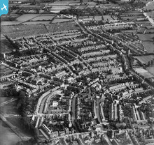
You can just see the river Thames to the west of Meadow Lane in the top right-hand corner of this image. I assume the church tower on the corner of Jackdaw Lane and Iffley Road must be the church of St Edmund and St Frideswide before the site was expanded in 1930 to create Greyfriars. |
Antonia Harland-Lang |
Wednesday 14th of November 2012 07:56:23 PM |
Is the church middle left on the edge of the picture St Mary and St John? |
Joan Bellinger |
Wednesday 14th of November 2012 07:56:23 PM |