
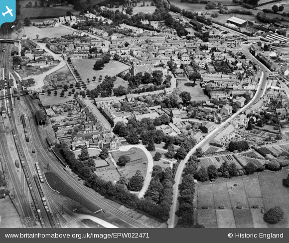
EPW022471 ENGLAND (1928). St Barnabas's Church and environs, Linslade, 1928
© Copyright OpenStreetMap contributors and licensed by the OpenStreetMap Foundation. 2026. Cartography is licensed as CC BY-SA.
Details
| Title | [EPW022471] St Barnabas's Church and environs, Linslade, 1928 |
| Reference | EPW022471 |
| Date | 9-August-1928 |
| Link | |
| Place name | LINSLADE |
| Parish | LEIGHTON-LINSLADE |
| District | |
| Country | ENGLAND |
| Easting / Northing | 491187, 224796 |
| Longitude / Latitude | -0.67411188301456, 51.913784435576 |
| National Grid Reference | SP912248 |
Pins

Mrs K |
Saturday 15th of August 2020 09:46:24 AM | |
|
rodent |
Tuesday 15th of December 2015 11:47:12 AM | |

melgibbs |
Thursday 26th of December 2013 08:15:56 PM | |
|
Vonderene |
Friday 23rd of August 2013 05:45:20 PM | |
 |
Gellandi |
Monday 24th of June 2013 08:13:14 PM |
|
roxeth |
Saturday 17th of November 2012 11:58:14 PM | |
|
roxeth |
Saturday 17th of November 2012 11:57:37 PM | |
|
Straberries |
Monday 16th of July 2012 04:51:45 PM | |
|
Straberries |
Monday 16th of July 2012 04:50:34 PM | |
|
Straberries |
Monday 16th of July 2012 04:49:29 PM | |
|
Straberries |
Monday 16th of July 2012 04:14:11 PM | |
|
JP1000 |
Sunday 1st of July 2012 03:51:26 PM | |
|
JP1000 |
Sunday 1st of July 2012 03:49:58 PM |
User Comment Contributions

The South End of Leighton Buzzard Station showing the engine shed and branch to Dunstable curving away on the bottom right of the photo, with the main line to the left. |
Puffpuffbuff |
Tuesday 26th of June 2012 08:16:17 AM |