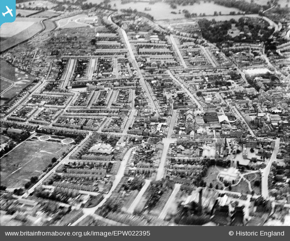
EPW022395 ENGLAND (1928). New Town, Luton, from the north-east, 1928
    © Copyright OpenStreetMap contributors and licensed by the OpenStreetMap Foundation. 2025. Cartography is licensed as CC BY-SA.
  
Nearby Images (7)
Details
| Title | [EPW022395] New Town, Luton, from the north-east, 1928 | 
| Reference | EPW022395 | 
| Date | 9-August-1928 | 
| Link | |
| Place name | LUTON | 
| Parish | |
| District | |
| Country | ENGLAND | 
| Easting / Northing | 509608, 221039 | 
| Longitude / Latitude | -0.4075616015495, 51.876693782828 | 
| National Grid Reference | TL096210 | 
Pins
|  Bolton Road |   Dennis Jackson | Thursday 11th of November 2021 01:17:39 PM | 
|  Gloucester Road |   Dennis Jackson | Thursday 11th of November 2021 01:16:44 PM | 
|  Manor Road |   Dennis Jackson | Thursday 11th of November 2021 01:15:02 PM | 
|  Memorial Park. |   Thameslink | Friday 4th of October 2019 12:07:29 AM | 
|  Tennyson Road. |   Thameslink | Friday 4th of October 2019 12:05:04 AM | 
|  Cambridge Street |   Pat | Saturday 30th of May 2015 03:40:26 PM | 
|  This House in Cambridge Street was Bombed during WW2 |   Paul525 | Monday 27th of May 2013 06:57:49 PM | 
|  Godfrey Dye Works. Then after Par-Tool Engineering until Demolitions. |   Paul525 | Monday 27th of May 2013 06:55:12 PM | 
|  St Paul's Church |   Paul525 | Monday 27th of May 2013 06:52:43 PM | 
|  The Windsor Castle Public House |   Paul525 | Monday 27th of May 2013 06:50:25 PM | 
|  Surrey Street Boys School up to 1967 |   Paul525 | Monday 27th of May 2013 06:46:18 PM | 
|  Queen Square Boys School |   Paul525 | Monday 27th of May 2013 06:44:32 PM | 
|  Manor Road Park |   gazza g | Sunday 13th of January 2013 01:32:15 PM | 
|  St Marys C of E Parish Church |   gazza g | Sunday 13th of January 2013 01:31:33 PM | 
User Comment Contributions
| St. Mary's Church, Luton, 30/06/2014 | Class31 | Tuesday 1st of July 2014 02:50:07 PM | 
 
             
  ![[EPW022395] New Town, Luton, from the north-east, 1928](http://britainfromabove.org.uk/sites/all/libraries/aerofilms-images/public/100x100/EPW/022/EPW022395.jpg) 
  
                                          ![[EPW022398] The town, Luton, from the south-east, 1928](http://britainfromabove.org.uk/sites/all/libraries/aerofilms-images/public/100x100/EPW/022/EPW022398.jpg) 
 ![[EPW019219] St Mary's Church, the Boiler and Engineering Works and the town, Luton, 1927](http://britainfromabove.org.uk/sites/all/libraries/aerofilms-images/public/100x100/EPW/019/EPW019219.jpg) 
 ![[EPW026494] St Mary's Church and the town centre, Luton, 1929](http://britainfromabove.org.uk/sites/all/libraries/aerofilms-images/public/100x100/EPW/026/EPW026494.jpg) 
 ![[EAW016040] The town, Luton, from the north-west, 1948. This image has been produced from a damaged negative.](http://britainfromabove.org.uk/sites/all/libraries/aerofilms-images/public/100x100/EAW/016/EAW016040.jpg) 
 ![[EPW022396] The town centre, Luton, from the north-east, 1928](http://britainfromabove.org.uk/sites/all/libraries/aerofilms-images/public/100x100/EPW/022/EPW022396.jpg) 
 ![[EPW053993] St Mary's Church and the town, Luton, 1937](http://britainfromabove.org.uk/sites/all/libraries/aerofilms-images/public/100x100/EPW/053/EPW053993.jpg)