
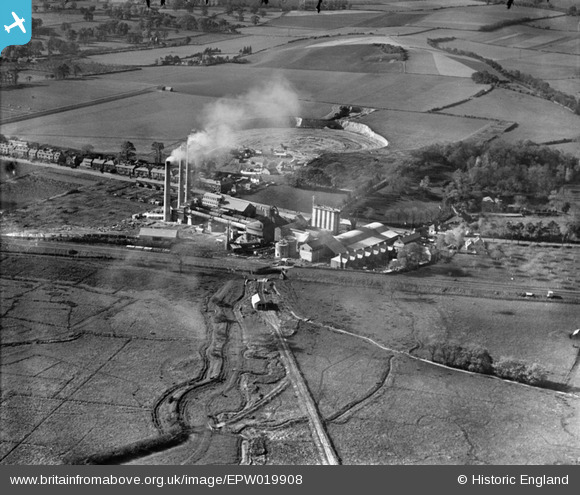
EPW019908 ENGLAND (1927). Holborough Cement Works and Quarry, Holborough, 1927
© Copyright OpenStreetMap contributors and licensed by the OpenStreetMap Foundation. 2026. Cartography is licensed as CC BY-SA.
Nearby Images (18)
EPW019908

EPW020924

EPW019906

EPW020922

EPW019907

EPW020923

EPW019901

EPW020921

EPW020920

EPW019911

EPW019912

EPW020919

EPW020918

EPW019903

EPW020925

EPW019902

EPW019904

EPW019909

Details
| Title | [EPW019908] Holborough Cement Works and Quarry, Holborough, 1927 |
| Reference | EPW019908 |
| Date | October-1927 |
| Link | |
| Place name | HOLBOROUGH |
| Parish | SNODLAND |
| District | |
| Country | ENGLAND |
| Easting / Northing | 570551, 162613 |
| Longitude / Latitude | 0.44870308415637, 51.336486822227 |
| National Grid Reference | TQ706626 |
Pins
Be the first to add a comment to this image!
User Comment Contributions
For details, history and many links, see [[http://www.cementkilns.co.uk/cement_kiln_holborough.html]]. |

Dylan Moore |
Thursday 18th of October 2012 09:20:18 PM |
Holborough |
Dylan Moore |
Tuesday 16th of October 2012 07:13:54 PM |
Picture of Holborough Cement Plant just before its acquisition by the Red Triangle Group. The plant operated 1924-1984. The third kiln had been installed the previous year. |
Dylan Moore |
Tuesday 16th of October 2012 12:52:18 PM |