
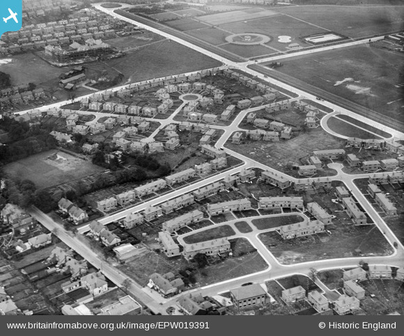
EPW019391 ENGLAND (1927). Arbor Drive and the Kingsway Estate, Burnage, 1927
© Copyright OpenStreetMap contributors and licensed by the OpenStreetMap Foundation. 2026. Cartography is licensed as CC BY-SA.
Nearby Images (3)
EPW019391

EPW019127

EPW019124

Details
| Title | [EPW019391] Arbor Drive and the Kingsway Estate, Burnage, 1927 |
| Reference | EPW019391 |
| Date | 30-September-1927 |
| Link | |
| Place name | BURNAGE |
| Parish | |
| District | |
| Country | ENGLAND |
| Easting / Northing | 386953, 393046 |
| Longitude / Latitude | -2.1964040380202, 53.433777436339 |
| National Grid Reference | SJ870930 |
Pins

Rick |
Friday 9th of August 2013 12:42:11 PM | |
|
John Ellis |
Monday 27th of August 2012 06:01:19 PM | |
|
John Ellis |
Monday 27th of August 2012 06:00:59 PM | |
|
John Ellis |
Monday 27th of August 2012 06:00:23 PM | |
|
John Ellis |
Monday 27th of August 2012 05:59:54 PM | |
|
John Ellis |
Monday 27th of August 2012 05:59:29 PM | |
|
John Ellis |
Monday 27th of August 2012 05:59:05 PM | |
|
John Ellis |
Monday 27th of August 2012 05:58:41 PM | |
|
John Ellis |
Monday 27th of August 2012 05:57:57 PM | |
|
John Ellis |
Monday 27th of August 2012 05:57:30 PM | |
|
John Ellis |
Monday 27th of August 2012 05:56:58 PM | |
|
John Ellis |
Monday 27th of August 2012 05:55:30 PM | |
|
John Ellis |
Monday 27th of August 2012 05:54:19 PM | |
|
John Ellis |
Monday 27th of August 2012 05:53:25 PM | |
|
John Ellis |
Monday 27th of August 2012 05:52:39 PM | |
|
John Ellis |
Monday 27th of August 2012 05:51:01 PM | |
|
John Ellis |
Monday 27th of August 2012 05:49:59 PM |