
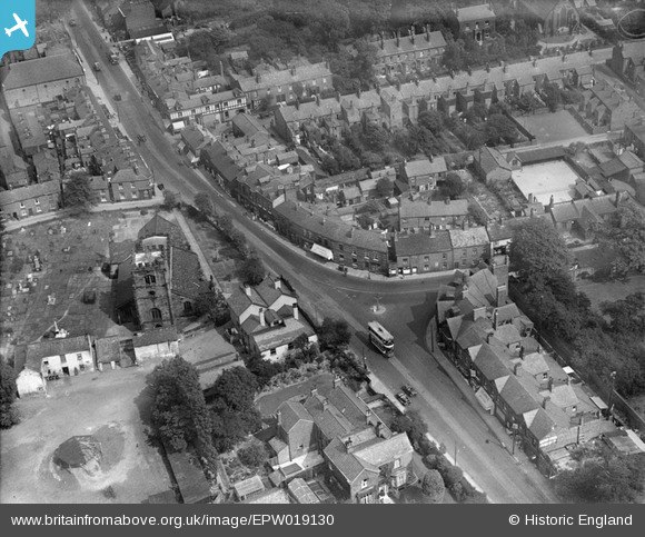
EPW019130 ENGLAND (1927). St Mary's Church and the High Street, Cheadle, 1927
© Copyright OpenStreetMap contributors and licensed by the OpenStreetMap Foundation. 2025. Cartography is licensed as CC BY-SA.
Nearby Images (4)
EPW019130

EPW018016

EPW018014

EPW019129

Details
| Title | [EPW019130] St Mary's Church and the High Street, Cheadle, 1927 |
| Reference | EPW019130 |
| Date | 4-August-1927 |
| Link | |
| Place name | CHEADLE |
| Parish | |
| District | |
| Country | ENGLAND |
| Easting / Northing | 385652, 388578 |
| Longitude / Latitude | -2.2157852010577, 53.393578420315 |
| National Grid Reference | SJ857886 |
Pins

John Ellis |
Monday 8th of December 2014 03:48:45 PM | |
|
John Ellis |
Tuesday 7th of August 2012 05:48:03 PM | |
|
John Ellis |
Tuesday 7th of August 2012 12:31:53 PM | |
I love the trams and trolley buses that are turning up in these photos! |
Whittocks |
Wednesday 8th of August 2012 10:24:36 PM |
|
John Ellis |
Tuesday 7th of August 2012 12:19:12 PM | |
|
John Ellis |
Tuesday 7th of August 2012 12:17:33 PM | |
|
John Ellis |
Tuesday 7th of August 2012 12:16:06 PM | |
|
John Ellis |
Tuesday 7th of August 2012 12:14:58 PM | |
|
John Ellis |
Tuesday 7th of August 2012 12:14:22 PM | |
|
John Ellis |
Tuesday 7th of August 2012 12:11:17 PM | |
|
John Ellis |
Tuesday 7th of August 2012 12:09:35 PM | |
|
John Ellis |
Tuesday 7th of August 2012 12:07:11 PM | |
|
John Ellis |
Tuesday 7th of August 2012 12:06:26 PM |