
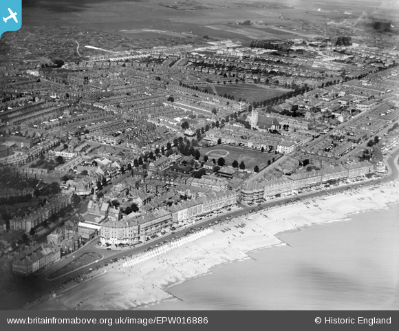
EPW016886 ENGLAND (1926). The seafront, Ordnance Field and environs, Eastbourne, from the south-east, 1926
© Copyright OpenStreetMap contributors and licensed by the OpenStreetMap Foundation. 2026. Cartography is licensed as CC BY-SA.
Nearby Images (3)
EPW016886

EAW022968

EPW051368

Details
| Title | [EPW016886] The seafront, Ordnance Field and environs, Eastbourne, from the south-east, 1926 |
| Reference | EPW016886 |
| Date | August-1926 |
| Link | |
| Place name | EASTBOURNE |
| Parish | |
| District | |
| Country | ENGLAND |
| Easting / Northing | 562017, 99371 |
| Longitude / Latitude | 0.29797105281717, 50.770699178149 |
| National Grid Reference | TV620994 |
Pins

Brigid |
Sunday 31st of January 2016 05:55:02 PM | |
|
Brigid |
Sunday 31st of January 2016 05:54:59 PM | |
|
Mikeo1938 |
Friday 10th of October 2014 10:40:38 PM | |
|
DLB |
Thursday 12th of July 2012 02:29:30 PM | |
In fact, Seaside and not Seaside Road. |
Mikeo1938 |
Friday 10th of October 2014 10:42:57 PM |
|
DLB |
Thursday 12th of July 2012 02:25:47 PM | |
In fact, Seaside and not Seaside Road. |
Mikeo1938 |
Friday 10th of October 2014 10:43:32 PM |
|
DLB |
Thursday 12th of July 2012 02:24:15 PM | |
|
DLB |
Thursday 12th of July 2012 02:23:04 PM | |
Very interested in your comment about the Refuse Destructor. I have been trying for ages to get photos of it for a local history project but without success. I wonder if DLB or anyone else has any? |
tallstory |
Tuesday 4th of September 2012 12:23:32 PM |