
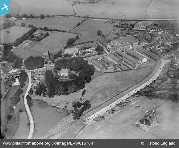
EPW016704 ENGLAND (1926). Norden House and St Paul's Church, Norden, 1926
© Copyright OpenStreetMap contributors and licensed by the OpenStreetMap Foundation. 2026. Cartography is licensed as CC BY-SA.
Nearby Images (2)
EPW016704

EPW016703

Details
| Title | [EPW016704] Norden House and St Paul's Church, Norden, 1926 |
| Reference | EPW016704 |
| Date | 29-August-1926 |
| Link | |
| Place name | NORDEN |
| Parish | |
| District | |
| Country | ENGLAND |
| Easting / Northing | 385979, 414489 |
| Longitude / Latitude | -2.2120267105327, 53.626511167414 |
| National Grid Reference | SD860145 |
Pins

JParr76 |
Friday 5th of December 2025 02:31:55 PM | |
|
JParr76 |
Friday 5th of December 2025 02:31:06 PM | |
|
JParr76 |
Friday 5th of December 2025 02:30:38 PM | |
|
JParr76 |
Friday 5th of December 2025 02:30:13 PM | |
|
JParr76 |
Friday 5th of December 2025 02:29:28 PM | |
|
JParr76 |
Friday 5th of December 2025 02:29:08 PM | |
|
JParr76 |
Friday 5th of December 2025 02:28:20 PM | |
|
JParr76 |
Friday 5th of December 2025 02:27:42 PM | |
|
JParr76 |
Friday 5th of December 2025 02:27:06 PM | |
|
JParr76 |
Friday 5th of December 2025 02:26:47 PM | |
|
JParr76 |
Friday 5th of December 2025 02:25:58 PM | |
|
JParr76 |
Friday 5th of December 2025 02:25:07 PM | |
|
JParr76 |
Friday 5th of December 2025 02:22:57 PM | |
|
JParr76 |
Friday 5th of December 2025 02:22:42 PM | |
|
JParr76 |
Friday 5th of December 2025 02:22:22 PM | |
|
JParr76 |
Friday 5th of December 2025 02:21:24 PM | |
|
JParr76 |
Friday 5th of December 2025 02:20:48 PM | |
|
JParr76 |
Friday 5th of December 2025 02:19:56 PM | |
|
JParr76 |
Friday 5th of December 2025 02:19:25 PM | |
|
kelvin |
Monday 6th of February 2017 12:29:46 AM | |

Class31 |
Monday 11th of March 2013 10:41:50 PM |
User Comment Contributions
Also Known locally as "Forty Row" thought to be the longest unbroken terrace in England. "Middens" outside toilets were built into a wall facing the doors, remains still there next to the cobbled road. Census 1911, 40 houses (count the chimneys) numbered 24 to 102 evens only, total number living there 190, 7 had 8 or more occupants. The occupations were mostly in the textile industry. I think there are at least 12 people at the front doors, watching the aeroplane ? The missing numbers appear around the corner on Clapgate St |
kelvin |
Sunday 5th of February 2017 11:17:26 PM |