
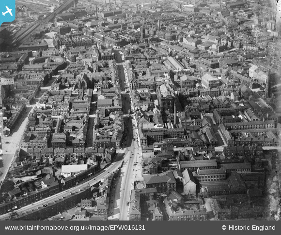
EPW016131 ENGLAND (1926). The Town Hall and environs, Huddersfield, 1926
© Copyright OpenStreetMap contributors and licensed by the OpenStreetMap Foundation. 2026. Cartography is licensed as CC BY-SA.
Nearby Images (7)
EPW016131

EPW016133

EPW045317

EPW016125

EPW016130

EPW045320

EPW024368

Details
| Title | [EPW016131] The Town Hall and environs, Huddersfield, 1926 |
| Reference | EPW016131 |
| Date | 2-July-1926 |
| Link | |
| Place name | HUDDERSFIELD |
| Parish | |
| District | |
| Country | ENGLAND |
| Easting / Northing | 414417, 416371 |
| Longitude / Latitude | -1.7818977549642, 53.643418072581 |
| National Grid Reference | SE144164 |
Pins

Javaboy |
Wednesday 4th of March 2020 07:29:18 PM | |
|
John W |
Saturday 17th of December 2016 04:20:42 PM | |
|
john h |
Wednesday 8th of July 2015 07:15:07 PM | |
|
FirthYorkshire |
Friday 26th of June 2015 10:50:48 PM | |
|
FirthYorkshire |
Friday 26th of June 2015 10:49:53 PM | |
|
Stan |
Sunday 21st of December 2014 02:35:42 PM | |
|
Stan |
Sunday 21st of December 2014 02:34:21 PM | |
|
Stan |
Sunday 21st of December 2014 02:30:26 PM | |
This is Manchester street. upperhead row is to the left, just out of shot. |
Martin |
Thursday 14th of May 2020 10:57:06 PM |
|
Stan |
Sunday 21st of December 2014 02:28:45 PM | |
|
Stan |
Sunday 21st of December 2014 02:27:43 PM | |
|
Stan |
Sunday 21st of December 2014 02:23:29 PM | |
|
Stan |
Sunday 21st of December 2014 02:23:07 PM | |
|
Stan |
Friday 19th of December 2014 04:45:21 PM | |
|
Stan |
Friday 19th of December 2014 04:26:09 PM | |
|
Stan |
Friday 19th of December 2014 04:25:46 PM | |
|
Stan |
Friday 19th of December 2014 04:24:59 PM | |
|
Maureen Teresa Hoare |
Friday 4th of April 2014 11:36:45 AM | |
I believe this is the Cloth Hall, also marked as "The Exchange" on maps. Demolished in 1930, although the entrance was re-erected in Ravensknowle Park. |
Tony D |
Friday 4th of April 2014 01:11:42 PM |
Definitely the Huddersfield Cloth Hall, Cloth Hall Street |
john h |
Wednesday 8th of July 2015 07:16:53 PM |
|
Al |
Sunday 22nd of September 2013 10:10:19 AM |
User Comment Contributions
the place left top is the former Cloth Hall. |
mr |
Tuesday 2nd of September 2014 05:11:41 PM |