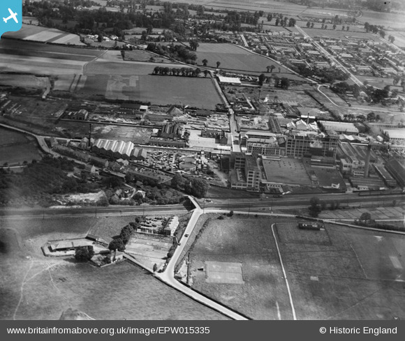
EPW015335 ENGLAND (1926). Gramophone Factories, Hayes, 1926
© Copyright OpenStreetMap contributors and licensed by the OpenStreetMap Foundation. 2026. Cartography is licensed as CC BY-SA.
Nearby Images (25)
Details
| Title | [EPW015335] Gramophone Factories, Hayes, 1926 |
| Reference | EPW015335 |
| Date | 1-June-1926 |
| Link | |
| Place name | HAYES |
| Parish | |
| District | |
| Country | ENGLAND |
| Easting / Northing | 509178, 179621 |
| Longitude / Latitude | -0.42676914247076, 51.504480293746 |
| National Grid Reference | TQ092796 |


![[EPW015335] Gramophone Factories, Hayes, 1926](http://britainfromabove.org.uk/sites/all/libraries/aerofilms-images/public/100x100/EPW/015/EPW015335.jpg)
![[EPW031825] Gramophone Company (HMV) factory buildings and environs, Hayes, 1930](http://britainfromabove.org.uk/sites/all/libraries/aerofilms-images/public/100x100/EPW/031/EPW031825.jpg)
![[EPW031824] Gramophone Company (HMV) factory buildings and environs, Hayes, 1930](http://britainfromabove.org.uk/sites/all/libraries/aerofilms-images/public/100x100/EPW/031/EPW031824.jpg)
![[EPW031826] Gramophone Company (HMV) factory buildings and environs, Hayes, 1930](http://britainfromabove.org.uk/sites/all/libraries/aerofilms-images/public/100x100/EPW/031/EPW031826.jpg)
![[EPW031832] The Great Western Railway, Gramophone Company (HMV) factory buildings and environs, Hayes, 1930](http://britainfromabove.org.uk/sites/all/libraries/aerofilms-images/public/100x100/EPW/031/EPW031832.jpg)
![[EPW031823] Gramophone Company (HMV) factory buildings and environs, Hayes, 1930](http://britainfromabove.org.uk/sites/all/libraries/aerofilms-images/public/100x100/EPW/031/EPW031823.jpg)
![[EPW008028] His Master's Voice Gramophone Works, Hayes, 1922](http://britainfromabove.org.uk/sites/all/libraries/aerofilms-images/public/100x100/EPW/008/EPW008028.jpg)
![[EPW031827] Gramophone Company (HMV) factory buildings and environs, Hayes, 1930](http://britainfromabove.org.uk/sites/all/libraries/aerofilms-images/public/100x100/EPW/031/EPW031827.jpg)
![[EPW015336] Gramophone Factories, Hayes, 1926](http://britainfromabove.org.uk/sites/all/libraries/aerofilms-images/public/100x100/EPW/015/EPW015336.jpg)
![[EPW031822] Gramophone Company (HMV) factory buildings and environs, Hayes, from the south, 1930](http://britainfromabove.org.uk/sites/all/libraries/aerofilms-images/public/100x100/EPW/031/EPW031822.jpg)
![[EPW015337] Gramophone Factories, Hayes, 1926](http://britainfromabove.org.uk/sites/all/libraries/aerofilms-images/public/100x100/EPW/015/EPW015337.jpg)
![[EPW031842] Gramophone Company (HMV) factory buildings and environs, Hayes, 1930](http://britainfromabove.org.uk/sites/all/libraries/aerofilms-images/public/100x100/EPW/031/EPW031842.jpg)
![[EPW005150] His Master's Voice Gramophone Factories, Hayes, 1920](http://britainfromabove.org.uk/sites/all/libraries/aerofilms-images/public/100x100/EPW/005/EPW005150.jpg)
![[EPW031830] The Great Western Railway, Gramophone Company (HMV) factory buildings and environs, Hayes, 1930](http://britainfromabove.org.uk/sites/all/libraries/aerofilms-images/public/100x100/EPW/031/EPW031830.jpg)
![[EPW005151] His Master's Voice Gramophone Factories, Hayes, 1920](http://britainfromabove.org.uk/sites/all/libraries/aerofilms-images/public/100x100/EPW/005/EPW005151.jpg)
![[EPW008027] His Master's Voice Gramophone Works, Hayes, 1922](http://britainfromabove.org.uk/sites/all/libraries/aerofilms-images/public/100x100/EPW/008/EPW008027.jpg)
![[EPW015332] Gramophone Factories, Hayes, 1926](http://britainfromabove.org.uk/sites/all/libraries/aerofilms-images/public/100x100/EPW/015/EPW015332.jpg)
![[EPW031839] Gramophone Company (HMV) factory buildings and environs, Hayes, 1930](http://britainfromabove.org.uk/sites/all/libraries/aerofilms-images/public/100x100/EPW/031/EPW031839.jpg)
![[EPW008026] His Master's Voice Gramophone Works, Hayes, 1922](http://britainfromabove.org.uk/sites/all/libraries/aerofilms-images/public/100x100/EPW/008/EPW008026.jpg)
![[EPW037590] The HMV Gramophone Factories, Hayes, 1932](http://britainfromabove.org.uk/sites/all/libraries/aerofilms-images/public/100x100/EPW/037/EPW037590.jpg)
![[EPW031829] Gramophone Company (HMV) factory buildings and environs, Hayes, from the south-west, 1930](http://britainfromabove.org.uk/sites/all/libraries/aerofilms-images/public/100x100/EPW/031/EPW031829.jpg)
![[EPW031821] Gramophone Company (HMV) factory buildings and environs, Hayes, 1930](http://britainfromabove.org.uk/sites/all/libraries/aerofilms-images/public/100x100/EPW/031/EPW031821.jpg)
![[EPW031828] Gramophone Company (HMV) factory buildings and environs, Hayes, from the south-west, 1930](http://britainfromabove.org.uk/sites/all/libraries/aerofilms-images/public/100x100/EPW/031/EPW031828.jpg)
![[EPW031833] The Grand Union Canal, Gramophone Company (HMV) factory buildings and environs, Hayes, from the south-west, 1930](http://britainfromabove.org.uk/sites/all/libraries/aerofilms-images/public/100x100/EPW/031/EPW031833.jpg)
![[EPW031831] Gramophone Company (HMV) factory buildings and environs, Hayes, from the south-west, 1930](http://britainfromabove.org.uk/sites/all/libraries/aerofilms-images/public/100x100/EPW/031/EPW031831.jpg)

