
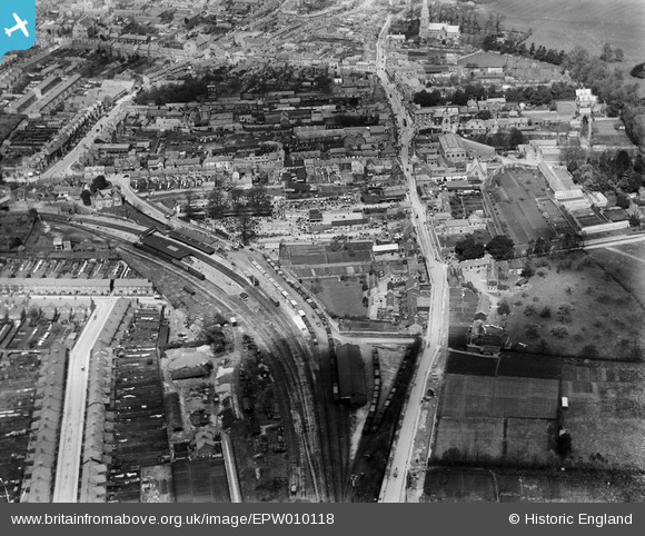
EPW010118 ENGLAND (1924). The station and High Street and environs, Swindon, 1924
© Copyright OpenStreetMap contributors and licensed by the OpenStreetMap Foundation. 2026. Cartography is licensed as CC BY-SA.
Nearby Images (5)
EPW010118

EAW006874

EPW059049

EAW006875

EPW010117

Details
| Title | [EPW010118] The station and High Street and environs, Swindon, 1924 |
| Reference | EPW010118 |
| Date | April-1924 |
| Link | |
| Place name | SWINDON |
| Parish | |
| District | |
| Country | ENGLAND |
| Easting / Northing | 415802, 183431 |
| Longitude / Latitude | -1.7720804292261, 51.549070766142 |
| National Grid Reference | SU158834 |
Pins

gerry-r |
Thursday 20th of June 2024 08:09:02 PM | |
|
NottmJas |
Saturday 16th of September 2023 10:35:19 PM | |
|
NottmJas |
Saturday 16th of September 2023 10:31:25 PM | |
|
gBr |
Friday 3rd of March 2017 02:46:35 PM | |
|
gBr |
Friday 3rd of March 2017 02:45:05 PM | |
|
alastair wallace |
Thursday 5th of November 2015 09:52:55 PM | |
|
alastair wallace |
Thursday 5th of November 2015 09:51:08 PM | |
|
gerry-r |
Monday 2nd of June 2014 11:55:35 PM | |
|
gerry-r |
Monday 2nd of June 2014 11:41:46 PM | |
|
MB |
Monday 6th of May 2013 10:12:18 AM | |
|
MB |
Monday 6th of May 2013 10:11:33 AM | |
Definitely! |
kjbuk |
Friday 23rd of August 2013 03:58:48 PM |
Swindon Town "A" box as opposed to "B" which is just off the bottom of this photograph. |
gerry-r |
Monday 2nd of June 2014 11:37:50 PM |
|
MB |
Monday 6th of May 2013 10:06:09 AM | |
|
MB |
Monday 6th of May 2013 10:05:33 AM |
User Comment Contributions
The station is Swindon Town on the Midland and South Western Joint line. The railway linked Andoversford in the north with Andover in the south, via Cirencester, Swindon, Marlborough and Savernake |
MB |
Monday 2nd of June 2014 11:32:54 PM |
M&SW JUNCTION Railway. NOT Joint, might have survived longer if it was. |
gerry-r |
Monday 2nd of June 2014 11:32:54 PM |