
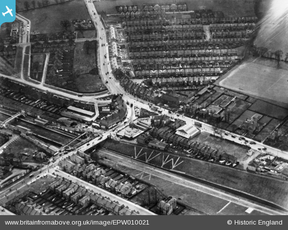
EPW010021 ENGLAND (1924). Wembley Hill Railway Station, The Triangle and Harrow Road, Wembley, 1924. This image has been produced from a copy-negative.
© Copyright OpenStreetMap contributors and licensed by the OpenStreetMap Foundation. 2026. Cartography is licensed as CC BY-SA.
Nearby Images (7)
EPW010021

EAW017621
 for the opening ceremony of the 1948 London Olympics, Wembley, 1948. This image has been produced from a print.")
EAW041245

EPW056262

EPW054286

EPW020870

EPW056261

Details
| Title | [EPW010021] Wembley Hill Railway Station, The Triangle and Harrow Road, Wembley, 1924. This image has been produced from a copy-negative. |
| Reference | EPW010021 |
| Date | April-1924 |
| Link | |
| Place name | WEMBLEY |
| Parish | |
| District | |
| Country | ENGLAND |
| Easting / Northing | 518877, 185224 |
| Longitude / Latitude | -0.28518171256361, 51.55288524494 |
| National Grid Reference | TQ189852 |
Pins

John Wass |
Saturday 29th of April 2017 08:47:19 PM | |
|
Sweet Pete |
Friday 1st of January 2016 04:05:55 PM | |
|
Sweet Pete |
Friday 1st of January 2016 04:05:18 PM | |

Class31 |
Monday 13th of October 2014 12:21:07 PM | |
|
Class31 |
Monday 13th of October 2014 12:19:29 PM | |
|
Class31 |
Monday 13th of October 2014 12:18:08 PM | |
|
Class31 |
Monday 13th of October 2014 12:17:31 PM | |
|
Class31 |
Monday 13th of October 2014 12:17:00 PM | |
|
Class31 |
Monday 13th of October 2014 12:15:35 PM |


User Comment Contributions
The station is now known as "Wembley Stadium". It is on the former Great Central (GC) line between Neasden, where it branched off the line from Marylebone to join the Great Western Railway at Northolt to form the GWR and GC Joint Railway line. The GCR had been absorbed into the L&NER the year before this photo was taken. |
John W |
Sunday 30th of April 2017 05:47:50 PM |