
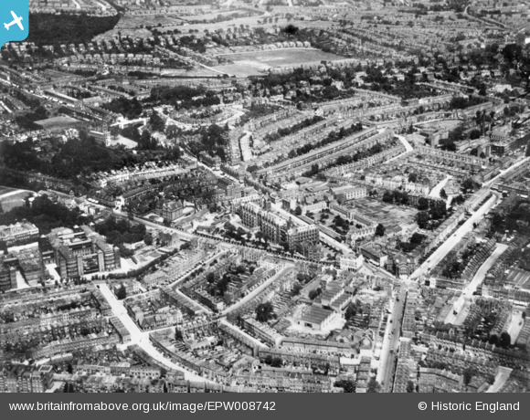
EPW008742 ENGLAND (1923). Archway Hospital, Whittington College and environs, Upper Holloway, 1923. This image has been produced from a copy-negative.
© Copyright OpenStreetMap contributors and licensed by the OpenStreetMap Foundation. 2026. Cartography is licensed as CC BY-SA.
Nearby Images (2)
EPW008742

EPW056663

Details
| Title | [EPW008742] Archway Hospital, Whittington College and environs, Upper Holloway, 1923. This image has been produced from a copy-negative. |
| Reference | EPW008742 |
| Date | 1923 |
| Link | |
| Place name | UPPER HOLLOWAY |
| Parish | |
| District | |
| Country | ENGLAND |
| Easting / Northing | 529288, 187058 |
| Longitude / Latitude | -0.13440914027912, 51.567078494907 |
| National Grid Reference | TQ293871 |
Pins

Joe90 |
Thursday 14th of November 2024 09:24:23 AM | |
|
Joe90 |
Thursday 14th of November 2024 08:33:54 AM | |
|
Fred |
Monday 31st of October 2016 02:53:08 PM | |
|
Coventry kid |
Thursday 30th of April 2015 03:55:30 PM | |
|
Coventry kid |
Thursday 30th of April 2015 03:54:36 PM | |
|
Coventry kid |
Thursday 30th of April 2015 03:53:49 PM | |
|
Coventry kid |
Thursday 30th of April 2015 03:52:30 PM | |
|
Coventry kid |
Thursday 30th of April 2015 03:51:57 PM | |
Giesbach I think - Elthorne is one more to the roght |
JulianN19 |
Sunday 20th of March 2016 11:48:02 AM |
|
Coventry kid |
Thursday 30th of April 2015 03:51:04 PM | |

Class31 |
Friday 23rd of January 2015 04:57:02 PM | |
|
Class31 |
Friday 23rd of January 2015 04:54:20 PM |


User Comment Contributions

Junction Road, Archway, 26/10/2015 |
Class31 |
Wednesday 28th of October 2015 08:56:48 AM |