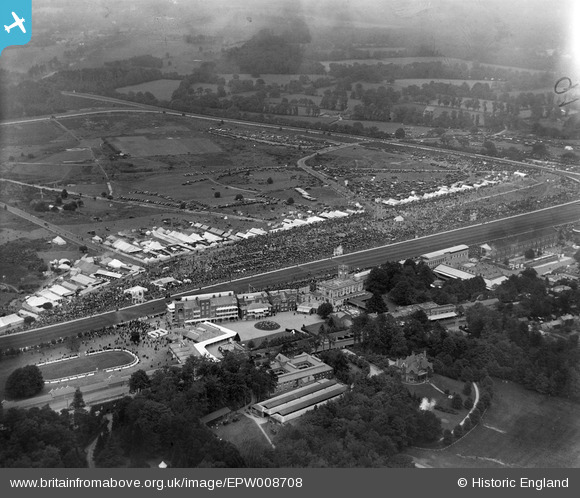
EPW008708 ENGLAND (1923). The Racecourse, Ascot, 1923
© Copyright OpenStreetMap contributors and licensed by the OpenStreetMap Foundation. 2026. Cartography is licensed as CC BY-SA.
Nearby Images (25)
Details
| Title | [EPW008708] The Racecourse, Ascot, 1923 |
| Reference | EPW008708 |
| Date | 1923 |
| Link | |
| Place name | ASCOT |
| Parish | SUNNINGHILL AND ASCOT |
| District | |
| Country | ENGLAND |
| Easting / Northing | 492111, 169045 |
| Longitude / Latitude | -0.67537895436037, 51.412440629886 |
| National Grid Reference | SU921690 |
Pins
Be the first to add a comment to this image!


![[EPW008708] The Racecourse, Ascot, 1923](http://britainfromabove.org.uk/sites/all/libraries/aerofilms-images/public/100x100/EPW/008/EPW008708.jpg)
![[EPW006703] Ascot, Royal Ascot, 1921](http://britainfromabove.org.uk/sites/all/libraries/aerofilms-images/public/100x100/EPW/006/EPW006703.jpg)
![[EPW006705] Ascot, Royal Ascot, 1921. This image has been produced from a damaged print.](http://britainfromabove.org.uk/sites/all/libraries/aerofilms-images/public/100x100/EPW/006/EPW006705.jpg)
![[EPW008707] The Grandstand and Royal Enclosure, Ascot, 1923](http://britainfromabove.org.uk/sites/all/libraries/aerofilms-images/public/100x100/EPW/008/EPW008707.jpg)
![[EAW042135] Ascot Racecourse in the snow, Ascot, 1952](http://britainfromabove.org.uk/sites/all/libraries/aerofilms-images/public/100x100/EAW/042/EAW042135.jpg)
![[EAW021006] New Stand at Ascot Race Course and environs, Ascot 1949. This image has been produced from a damaged negative.](http://britainfromabove.org.uk/sites/all/libraries/aerofilms-images/public/100x100/EAW/021/EAW021006.jpg)
![[EAW042136] Ascot Racecourse in the snow, Ascot, 1952](http://britainfromabove.org.uk/sites/all/libraries/aerofilms-images/public/100x100/EAW/042/EAW042136.jpg)
![[EPW008711] The Grandstand and Royal Enclosure, Ascot, 1923](http://britainfromabove.org.uk/sites/all/libraries/aerofilms-images/public/100x100/EPW/008/EPW008711.jpg)
![[EPW008704] Ascot, possibly the Ascot Gold Cup, 1923](http://britainfromabove.org.uk/sites/all/libraries/aerofilms-images/public/100x100/EPW/008/EPW008704.jpg)
![[EPW008709] The Racecourse, Ascot, 1923](http://britainfromabove.org.uk/sites/all/libraries/aerofilms-images/public/100x100/EPW/008/EPW008709.jpg)
![[EPW026290] Ascot Racecourse Royal Enclosure and grandstands, Ascot, 1929](http://britainfromabove.org.uk/sites/all/libraries/aerofilms-images/public/100x100/EPW/026/EPW026290.jpg)
![[EPW036160] Ascot Racecourse home straight and grandstands, Ascot, 1931](http://britainfromabove.org.uk/sites/all/libraries/aerofilms-images/public/100x100/EPW/036/EPW036160.jpg)
![[EPW006709] Ascot, Royal Ascot, from the south, 1921. This image has been produced from a damaged print.](http://britainfromabove.org.uk/sites/all/libraries/aerofilms-images/public/100x100/EPW/006/EPW006709.jpg)
![[EPW006707] Ascot, Royal Ascot, 1921. This image has been produced from a damaged print.](http://britainfromabove.org.uk/sites/all/libraries/aerofilms-images/public/100x100/EPW/006/EPW006707.jpg)
![[EPW013401] Ascot, Royal Ascot, 1925](http://britainfromabove.org.uk/sites/all/libraries/aerofilms-images/public/100x100/EPW/013/EPW013401.jpg)
![[EAW022117] Ascot Racecourse, Ascot, from the west, 1949](http://britainfromabove.org.uk/sites/all/libraries/aerofilms-images/public/100x100/EAW/022/EAW022117.jpg)
![[EPW026285] Ascot Racecourse Royal Enclosure and grandstands, Ascot, 1929](http://britainfromabove.org.uk/sites/all/libraries/aerofilms-images/public/100x100/EPW/026/EPW026285.jpg)
![[EPW008705] The Grandstand and Royal Enclosure, Ascot, 1923](http://britainfromabove.org.uk/sites/all/libraries/aerofilms-images/public/100x100/EPW/008/EPW008705.jpg)
![[EPW026286] Ascot Racecourse New Stand, Ascot, 1929](http://britainfromabove.org.uk/sites/all/libraries/aerofilms-images/public/100x100/EPW/026/EPW026286.jpg)
![[EPW013441] Ascot, Royal Ascot, 1925. This image has been produced from a print.](http://britainfromabove.org.uk/sites/all/libraries/aerofilms-images/public/100x100/EPW/013/EPW013441.jpg)
![[EPW006704] Ascot, Royal Ascot, 1921. This image has been produced from a print.](http://britainfromabove.org.uk/sites/all/libraries/aerofilms-images/public/100x100/EPW/006/EPW006704.jpg)
![[EAW042137] Ascot Racecourse in the snow, Ascot, 1952](http://britainfromabove.org.uk/sites/all/libraries/aerofilms-images/public/100x100/EAW/042/EAW042137.jpg)
![[EPW026284] Ascot Racecourse home straight, grandstands and paddocks, Ascot, 1929](http://britainfromabove.org.uk/sites/all/libraries/aerofilms-images/public/100x100/EPW/026/EPW026284.jpg)
![[EPW006706] Ascot, Royal Ascot, 1921. This image has been produced from a damaged print.](http://britainfromabove.org.uk/sites/all/libraries/aerofilms-images/public/100x100/EPW/006/EPW006706.jpg)
![[EPW026289] The High Street, Ascot, 1929](http://britainfromabove.org.uk/sites/all/libraries/aerofilms-images/public/100x100/EPW/026/EPW026289.jpg)