
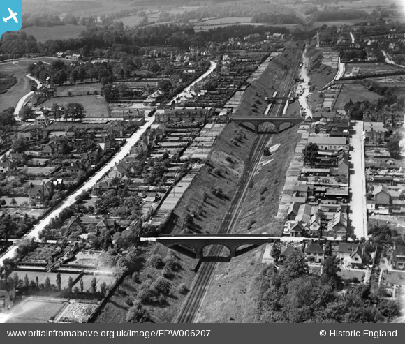
EPW006207 ENGLAND (1921). The railway cutting, Gerrards Cross, 1921
© Copyright OpenStreetMap contributors and licensed by the OpenStreetMap Foundation. 2026. Cartography is licensed as CC BY-SA.
Nearby Images (2)
EPW006207

EAW043438

Details
| Title | [EPW006207] The railway cutting, Gerrards Cross, 1921 |
| Reference | EPW006207 |
| Date | April-1921 |
| Link | |
| Place name | GERRARDS CROSS |
| Parish | GERRARDS CROSS |
| District | |
| Country | ENGLAND |
| Easting / Northing | 500425, 188566 |
| Longitude / Latitude | -0.55029905480267, 51.586515481247 |
| National Grid Reference | TQ004886 |
Pins
.JPG)
Colin1949 |
Wednesday 5th of March 2014 04:53:56 PM | |
Lynda Tubbs |
Wednesday 5th of February 2014 01:43:32 PM | |

moses72 |
Tuesday 8th of October 2013 03:11:45 PM | |
|
moses72 |
Tuesday 8th of October 2013 03:06:59 PM | |
Spent hours fishing and sailing boats here in the '60's |
Nick Cooper |
Saturday 26th of April 2014 01:38:29 PM |
|
moses72 |
Tuesday 8th of October 2013 03:06:16 PM | |
|
moses72 |
Tuesday 8th of October 2013 03:05:01 PM | |
|
moses72 |
Tuesday 8th of October 2013 03:03:55 PM | |
|
moses72 |
Tuesday 8th of October 2013 03:01:31 PM | |
|
moses72 |
Tuesday 8th of October 2013 03:01:07 PM |
User Comment Contributions
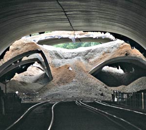
The tunnel collapse whilst under construction |
Colin1949 |
Wednesday 5th of March 2014 04:49:20 PM |