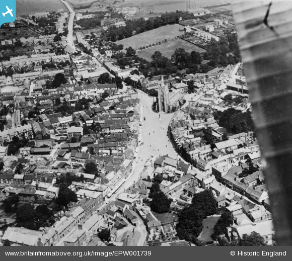
EPW001739 ENGLAND (1920). Market Hill and environs, Sudbury, 1920. This image has been produced from a copy-negative.
© Copyright OpenStreetMap contributors and licensed by the OpenStreetMap Foundation. 2026. Cartography is licensed as CC BY-SA.
Nearby Images (18)
Details
| Title | [EPW001739] Market Hill and environs, Sudbury, 1920. This image has been produced from a copy-negative. |
| Reference | EPW001739 |
| Date | June-1920 |
| Link | |
| Place name | SUDBURY |
| Parish | SUDBURY |
| District | |
| Country | ENGLAND |
| Easting / Northing | 587376, 241315 |
| Longitude / Latitude | 0.73225127478986, 52.038104026534 |
| National Grid Reference | TL874413 |
Pins
Be the first to add a comment to this image!


![[EPW001739] Market Hill and environs, Sudbury, 1920. This image has been produced from a copy-negative.](http://britainfromabove.org.uk/sites/all/libraries/aerofilms-images/public/100x100/EPW/001/EPW001739.jpg)
![[EAW029735] St Peter's Church and the town centre, Sudbury, 1950](http://britainfromabove.org.uk/sites/all/libraries/aerofilms-images/public/100x100/EAW/029/EAW029735.jpg)
![[EAW029736] St Peter's Church and the town, Sudbury, 1950](http://britainfromabove.org.uk/sites/all/libraries/aerofilms-images/public/100x100/EAW/029/EAW029736.jpg)
![[EPW025896] St Peter's Church and the Market Place, Sudbury, 1929](http://britainfromabove.org.uk/sites/all/libraries/aerofilms-images/public/100x100/EPW/025/EPW025896.jpg)
![[EPW025900] St Peter's Church and the town centre, Sudbury, 1929](http://britainfromabove.org.uk/sites/all/libraries/aerofilms-images/public/100x100/EPW/025/EPW025900.jpg)
![[EAW042074] St Peter's Church and Market Hill, Sudbury, 1952. This image has been produced from a damaged negative.](http://britainfromabove.org.uk/sites/all/libraries/aerofilms-images/public/100x100/EAW/042/EAW042074.jpg)
![[EPW025895] St Peter's Church and the Market Place, Sudbury, 1929](http://britainfromabove.org.uk/sites/all/libraries/aerofilms-images/public/100x100/EPW/025/EPW025895.jpg)
![[EAW042076] St Peter's Church and Market Hill, Sudbury, 1952](http://britainfromabove.org.uk/sites/all/libraries/aerofilms-images/public/100x100/EAW/042/EAW042076.jpg)
![[EAW042075] St Peter's Church and the town centre, Sudbury, 1952. This image has been produced from a damaged negative.](http://britainfromabove.org.uk/sites/all/libraries/aerofilms-images/public/100x100/EAW/042/EAW042075.jpg)
![[EPW001737] The town, Sudbury, 1920. This image has been produced from a copy-negative.](http://britainfromabove.org.uk/sites/all/libraries/aerofilms-images/public/100x100/EPW/001/EPW001737.jpg)
![[EAW042078] Wheelers Ltd King Street Saw Mill and St Peter's Church, Sudbury, 1952. This image was marked by Aerofilms Ltd for photo editing.](http://britainfromabove.org.uk/sites/all/libraries/aerofilms-images/public/100x100/EAW/042/EAW042078.jpg)
![[EAW042077] Wheelers Ltd King Street Saw Mill, Sudbury, 1952. This image was marked by Aerofilms Ltd for photo editing.](http://britainfromabove.org.uk/sites/all/libraries/aerofilms-images/public/100x100/EAW/042/EAW042077.jpg)
![[EAW042080] Wheelers Ltd King Street Saw Mill and the surrounding area, Sudbury, 1952. This image was marked by Aerofilms Ltd for photo editing.](http://britainfromabove.org.uk/sites/all/libraries/aerofilms-images/public/100x100/EAW/042/EAW042080.jpg)
![[EAW042079] Wheelers Ltd King Street Saw Mill and the surrounding area, Sudbury, 1952. This image was marked by Aerofilms Ltd for photo editing.](http://britainfromabove.org.uk/sites/all/libraries/aerofilms-images/public/100x100/EAW/042/EAW042079.jpg)
![[EAW042085] Wheelers Ltd Cornard Road Timber Yard and King Street Saw Mill, Sudbury, 1952. This image was marked by Aerofilms Ltd for photo editing.](http://britainfromabove.org.uk/sites/all/libraries/aerofilms-images/public/100x100/EAW/042/EAW042085.jpg)
![[EAW042084] Wheelers Ltd Cornard Road Timber Yard and the surrounding area, Sudbury, 1952](http://britainfromabove.org.uk/sites/all/libraries/aerofilms-images/public/100x100/EAW/042/EAW042084.jpg)
![[EAW042081] Wheelers Ltd Cornard Road Timber Yard, Sudbury, 1952. This image was marked by Aerofilms Ltd for photo editing.](http://britainfromabove.org.uk/sites/all/libraries/aerofilms-images/public/100x100/EAW/042/EAW042081.jpg)
![[EAW042083] Wheelers Ltd Cornard Road Timber Yard, Sudbury, 1952. This image was marked by Aerofilms Ltd for photo editing.](http://britainfromabove.org.uk/sites/all/libraries/aerofilms-images/public/100x100/EAW/042/EAW042083.jpg)