
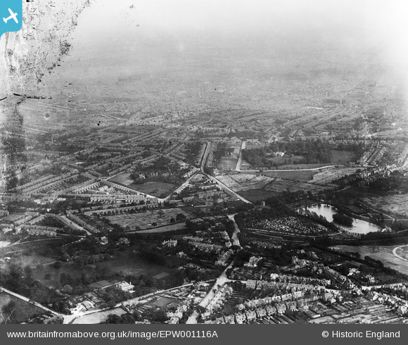
EPW001116A ENGLAND (1920). The northern area of the city, Birmingham, from the north-west, 1920
© Copyright OpenStreetMap contributors and licensed by the OpenStreetMap Foundation. 2026. Cartography is licensed as CC BY-SA.
Details
| Title | [EPW001116A] The northern area of the city, Birmingham, from the north-west, 1920 |
| Reference | EPW001116A |
| Date | May-1920 |
| Link | |
| Place name | BIRMINGHAM |
| Parish | |
| District | |
| Country | ENGLAND |
| Easting / Northing | 405491, 290579 |
| Longitude / Latitude | -1.9190797857925, 52.512706418254 |
| National Grid Reference | SP055906 |
Pins

BhamChris |
Sunday 2nd of February 2014 09:09:18 PM | |
|
BhamChris |
Sunday 2nd of February 2014 09:07:04 PM | |
|
BhamChris |
Sunday 2nd of February 2014 09:05:36 PM | |
|
DianaD |
Wednesday 10th of April 2013 11:14:33 PM | |
|
Rekrap |
Wednesday 17th of October 2012 09:17:03 AM | |

Class31 |
Friday 6th of July 2012 05:06:14 PM | |
|
Class31 |
Friday 6th of July 2012 05:05:23 PM | |
|
Class31 |
Friday 6th of July 2012 05:03:16 PM | |
|
Class31 |
Friday 6th of July 2012 05:00:22 PM |
User Comment Contributions
Thanks for adding the location of these allotments Diana - they just creep in at the edge of the image. Perhaps we will find clearer views in the negatives still to be conserved, digitised and catalogued. |
Alison Cutforth |
Friday 3rd of May 2013 06:28:30 PM |
Dear all, That’s great; we’ve reviewed your comments and thanks to your help we can update the catalogue. The revised record with the correct location will appear here in due course. It's great having fresh eyes with local knowledge to look at these unidentified images. Yours, Katy Britain from Above Cataloguing Team Leader |
Katy Whitaker |
Tuesday 23rd of October 2012 09:53:16 AM |
Handsworth Wood, West Midlands, viewed from the west. |
Tony D |
Friday 6th of July 2012 12:00:02 PM |