
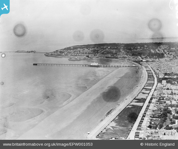
EPW001053 ENGLAND (1920). View of Weston-Super-Mare, the Grand Pier, Knightstone and Birnbeck Island, Weston-Super-Mare, from the south, 1920
© Copyright OpenStreetMap contributors and licensed by the OpenStreetMap Foundation. 2026. Cartography is licensed as CC BY-SA.
Nearby Images (2)
EPW001053

EAW025152
 and Grand Pier, Weston-super-Mare, from the south, 1949")
Details
| Title | [EPW001053] View of Weston-Super-Mare, the Grand Pier, Knightstone and Birnbeck Island, Weston-Super-Mare, from the south, 1920 |
| Reference | EPW001053 |
| Date | May-1920 |
| Link | |
| Place name | WESTON-SUPER-MARE |
| Parish | WESTON-SUPER-MARE |
| District | |
| Country | ENGLAND |
| Easting / Northing | 331350, 160350 |
| Longitude / Latitude | -2.9856178774952, 51.337587722687 |
| National Grid Reference | ST314604 |
Pins

Pete L |
Monday 13th of July 2015 10:37:04 PM | |
|
Pete L |
Monday 13th of July 2015 10:34:35 PM | |
|
Pete L |
Monday 13th of July 2015 10:33:25 PM | |

Alan McFaden |
Saturday 19th of October 2013 02:58:04 PM | |
|
Alan McFaden |
Saturday 19th of October 2013 02:57:10 PM | |
|
Alan McFaden |
Saturday 19th of October 2013 02:56:07 PM | |
|
Alan McFaden |
Saturday 19th of October 2013 02:55:17 PM |


User Comment Contributions
Date of this image is incorrect as the Grand Pier was built to this length in 1906 and the extension was removed by 1916. |
Pete L |
Monday 13th of July 2015 10:26:35 PM |